You are here: Home > Network List > YB13 - Continental Dynamics/Cent. Anatolian Tectonics:Surface to Mantle Dynamics During Stations List
> Station AT16 Ekinozu,Maras,Turkey > Earthquake Result Viewer
AT16 Ekinozu,Maras,Turkey - Earthquake Result Viewer
| Earthquake location: |
Ryukyu Islands, Japan |
| Earthquake latitude/longitude: |
27.4/127.4 |
| Earthquake time(UTC): |
2014/03/02 (061) 20:11:23 GMT |
| Earthquake Depth: |
119 km |
| Earthquake Magnitude: |
6.5 MWW, 6.4 MWB, 6.5 MWC, 6.6 MI, 6.7 MI |
| Earthquake Catalog/Contributor: |
NEIC PDE/NEIC COMCAT |
|
| Network: |
YB Continental Dynamics/Cent. Anatolian Tectonics:Surface to Mantle Dynamics During |
| Station: |
AT16 Ekinozu,Maras,Turkey |
| Lat/Lon: |
38.08 N/37.14 E |
| Elevation: |
1279 m |
|
| Distance: |
73.8 deg |
| Az: |
304.75 deg |
| Baz: |
67.74 deg |
| Ray Param: |
0.05245314 |
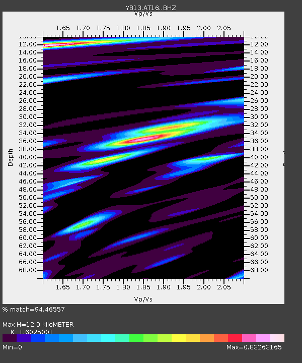
| Estimated Moho Depth: |
12.0 km |
| Estimated Crust Vp/Vs: |
1.60 |
| Assumed Crust Vp: |
6.35 km/s |
| Estimated Crust Vs: |
3.963 km/s |
| Estimated Crust Poisson's Ratio: |
0.18 |
|
| Radial Match: |
94.46557 % |
| Radial Bump: |
400 |
| Transverse Match: |
92.20733 % |
| Transverse Bump: |
400 |
| SOD ConfigId: |
3390531 |
| Insert Time: |
2019-04-10 12:05:23.075 +0000 |
| GWidth: |
2.5 |
| Max Bumps: |
400 |
| Tol: |
0.001 |
|

Signal To Noise
| Channel | StoN | STA | LTA |
| YB:AT16: :BHZ:20140302T20:22:13.20002Z | 58.53473 | 5.252776E-6 | 8.973777E-8 |
| YB:AT16: :BHN:20140302T20:22:13.20002Z | 12.083567 | 9.4898616E-7 | 7.8535265E-8 |
| YB:AT16: :BHE:20140302T20:22:13.20002Z | 14.754867 | 1.570946E-6 | 1.06469685E-7 |
| Arrivals |
| Ps | 1.2 SECOND |
| PpPs | 4.7 SECOND |
| PsPs/PpSs | 5.9 SECOND |


