You are here: Home > Network List > TA - USArray Transportable Network (new EarthScope stations) Stations List
> Station L31A Butterfield Farm, Chambers, NE, USA > Earthquake Result Viewer
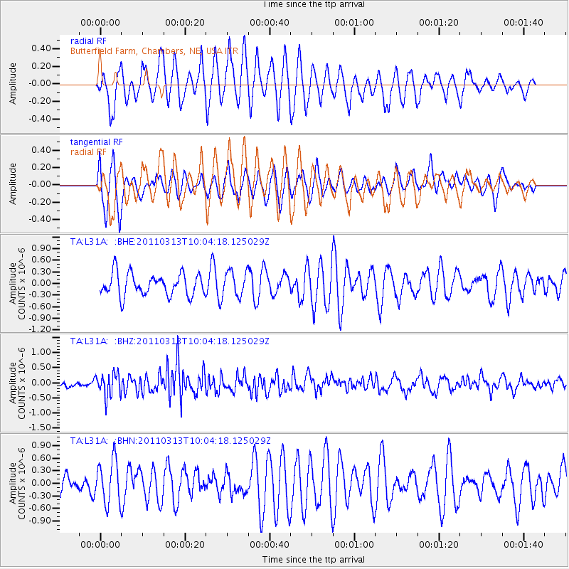
L31A Butterfield Farm, Chambers, NE, USA - Earthquake Result Viewer
*The percent match for this event was below the threshold and hence no stack was calculated.
| Earthquake location: |
Near East Coast Of Honshu, Japan |
| Earthquake latitude/longitude: |
38.8/141.9 |
| Earthquake time(UTC): |
2011/03/13 (072) 09:52:30 GMT |
| Earthquake Depth: |
33 km |
| Earthquake Magnitude: |
5.6 MW, 5.0 MS, 5.4 MB, 5.6 MW |
| Earthquake Catalog/Contributor: |
WHDF/NEIC |
|
| Network: |
TA USArray Transportable Network (new EarthScope stations) |
| Station: |
L31A Butterfield Farm, Chambers, NE, USA |
| Lat/Lon: |
42.18 N/98.84 W |
| Elevation: |
670 m |
|
| Distance: |
82.3 deg |
| Az: |
40.851 deg |
| Baz: |
316.598 deg |
| Ray Param: |
$rayparam |
*The percent match for this event was below the threshold and hence was not used in the summary stack. |
|
| Radial Match: |
59.476395 % |
| Radial Bump: |
371 |
| Transverse Match: |
57.975277 % |
| Transverse Bump: |
396 |
| SOD ConfigId: |
356183 |
| Insert Time: |
2011-08-20 20:21:27.128 +0000 |
| GWidth: |
2.5 |
| Max Bumps: |
400 |
| Tol: |
0.001 |
|
Signal To Noise
| Channel | StoN | STA | LTA |
| TA:L31A: :BHZ:20110313T10:04:18.125029Z | 3.90021 | 3.783097E-7 | 9.699726E-8 |
| TA:L31A: :BHN:20110313T10:04:18.125029Z | 1.8317454 | 5.2962207E-7 | 2.891352E-7 |
| TA:L31A: :BHE:20110313T10:04:18.125029Z | 1.1118251 | 3.1443093E-7 | 2.828061E-7 |
| Arrivals |
| Ps | |
| PpPs | |
| PsPs/PpSs | |


