You are here: Home > Network List > YB13 - Continental Dynamics/Cent. Anatolian Tectonics:Surface to Mantle Dynamics During Stations List
> Station AT32 Orhanli,Nigde,Turkey > Earthquake Result Viewer
AT32 Orhanli,Nigde,Turkey - Earthquake Result Viewer
| Earthquake location: |
Ryukyu Islands, Japan |
| Earthquake latitude/longitude: |
27.4/127.4 |
| Earthquake time(UTC): |
2014/03/02 (061) 20:11:23 GMT |
| Earthquake Depth: |
119 km |
| Earthquake Magnitude: |
6.5 MWW, 6.4 MWB, 6.5 MWC, 6.6 MI, 6.7 MI |
| Earthquake Catalog/Contributor: |
NEIC PDE/NEIC COMCAT |
|
| Network: |
YB Continental Dynamics/Cent. Anatolian Tectonics:Surface to Mantle Dynamics During |
| Station: |
AT32 Orhanli,Nigde,Turkey |
| Lat/Lon: |
38.30 N/34.89 E |
| Elevation: |
1504 m |
|
| Distance: |
75.4 deg |
| Az: |
305.665 deg |
| Baz: |
66.599 deg |
| Ray Param: |
0.051424965 |
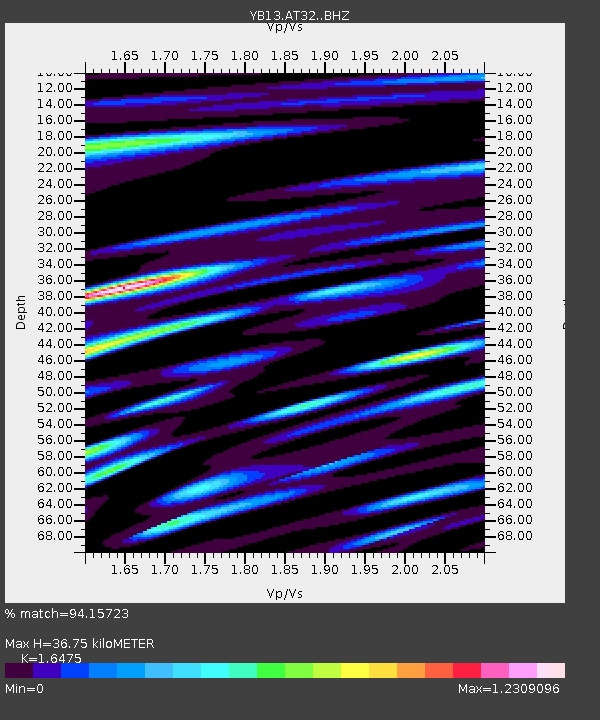
| Estimated Moho Depth: |
36.75 km |
| Estimated Crust Vp/Vs: |
1.65 |
| Assumed Crust Vp: |
6.35 km/s |
| Estimated Crust Vs: |
3.854 km/s |
| Estimated Crust Poisson's Ratio: |
0.21 |
|
| Radial Match: |
94.15723 % |
| Radial Bump: |
400 |
| Transverse Match: |
91.087494 % |
| Transverse Bump: |
400 |
| SOD ConfigId: |
3390531 |
| Insert Time: |
2019-04-10 12:05:33.917 +0000 |
| GWidth: |
2.5 |
| Max Bumps: |
400 |
| Tol: |
0.001 |
|

Signal To Noise
| Channel | StoN | STA | LTA |
| YB:AT32: :BHZ:20140302T20:22:22.119026Z | 56.589226 | 4.3642276E-6 | 7.712118E-8 |
| YB:AT32: :BHN:20140302T20:22:22.119026Z | 15.185052 | 1.3717773E-6 | 9.033735E-8 |
| YB:AT32: :BHE:20140302T20:22:22.119026Z | 17.533453 | 1.891146E-6 | 1.0785931E-7 |
| Arrivals |
| Ps | 3.9 SECOND |
| PpPs | 15 SECOND |
| PsPs/PpSs | 19 SECOND |


