You are here: Home > Network List > TA - USArray Transportable Network (new EarthScope stations) Stations List
> Station W37B Quinton, OK, USA > Earthquake Result Viewer
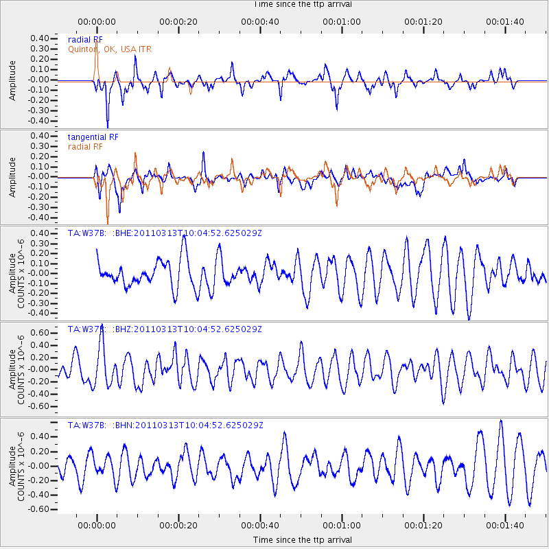
W37B Quinton, OK, USA - Earthquake Result Viewer
*The percent match for this event was below the threshold and hence no stack was calculated.
| Earthquake location: |
Near East Coast Of Honshu, Japan |
| Earthquake latitude/longitude: |
38.8/141.9 |
| Earthquake time(UTC): |
2011/03/13 (072) 09:52:30 GMT |
| Earthquake Depth: |
33 km |
| Earthquake Magnitude: |
5.6 MW, 5.0 MS, 5.4 MB, 5.6 MW |
| Earthquake Catalog/Contributor: |
WHDF/NEIC |
|
| Network: |
TA USArray Transportable Network (new EarthScope stations) |
| Station: |
W37B Quinton, OK, USA |
| Lat/Lon: |
35.14 N/95.43 W |
| Elevation: |
279 m |
|
| Distance: |
89.3 deg |
| Az: |
43.602 deg |
| Baz: |
318.923 deg |
| Ray Param: |
$rayparam |
*The percent match for this event was below the threshold and hence was not used in the summary stack. |
|
| Radial Match: |
61.420395 % |
| Radial Bump: |
340 |
| Transverse Match: |
55.981617 % |
| Transverse Bump: |
384 |
| SOD ConfigId: |
356183 |
| Insert Time: |
2011-08-20 20:40:05.114 +0000 |
| GWidth: |
2.5 |
| Max Bumps: |
400 |
| Tol: |
0.001 |
|
Signal To Noise
| Channel | StoN | STA | LTA |
| TA:W37B: :BHZ:20110313T10:04:52.625029Z | 2.0895405 | 3.3561352E-7 | 1.6061594E-7 |
| TA:W37B: :BHN:20110313T10:04:52.625029Z | 1.0524946 | 1.3944465E-7 | 1.3248965E-7 |
| TA:W37B: :BHE:20110313T10:04:52.625029Z | 1.017066 | 1.3689963E-7 | 1.346025E-7 |
| Arrivals |
| Ps | |
| PpPs | |
| PsPs/PpSs | |


