You are here: Home > Network List > US - United States National Seismic Network Stations List
> Station EGMT Eagleton, Montana, USA > Earthquake Result Viewer
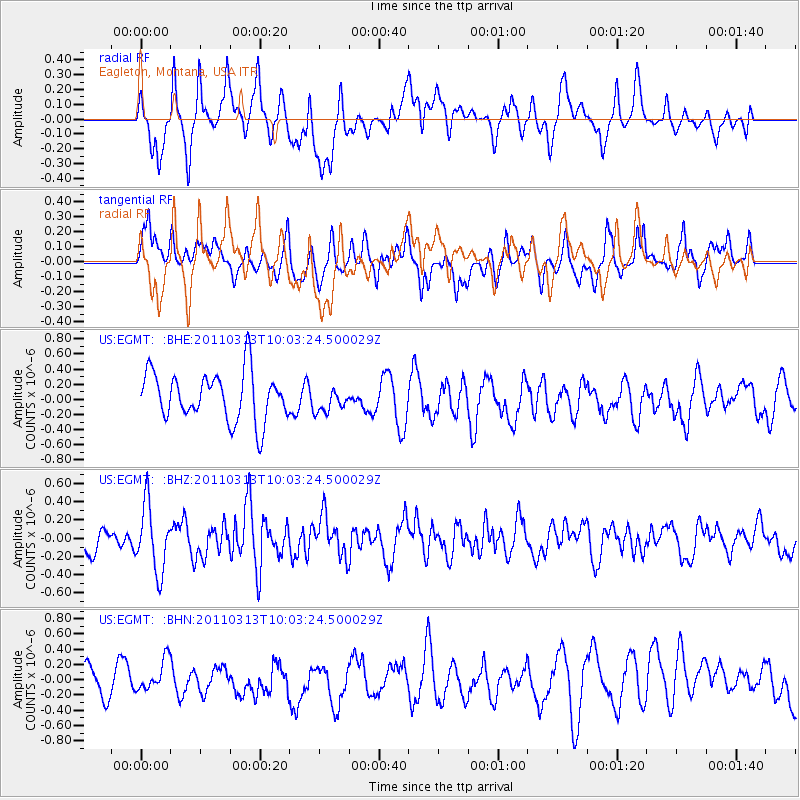
EGMT Eagleton, Montana, USA - Earthquake Result Viewer
*The percent match for this event was below the threshold and hence no stack was calculated.
| Earthquake location: |
Near East Coast Of Honshu, Japan |
| Earthquake latitude/longitude: |
38.8/141.9 |
| Earthquake time(UTC): |
2011/03/13 (072) 09:52:30 GMT |
| Earthquake Depth: |
33 km |
| Earthquake Magnitude: |
5.6 MW, 5.0 MS, 5.4 MB, 5.6 MW |
| Earthquake Catalog/Contributor: |
WHDF/NEIC |
|
| Network: |
US United States National Seismic Network |
| Station: |
EGMT Eagleton, Montana, USA |
| Lat/Lon: |
48.02 N/109.75 W |
| Elevation: |
1055 m |
|
| Distance: |
72.7 deg |
| Az: |
41.857 deg |
| Baz: |
309.088 deg |
| Ray Param: |
$rayparam |
*The percent match for this event was below the threshold and hence was not used in the summary stack. |
|
| Radial Match: |
61.702103 % |
| Radial Bump: |
400 |
| Transverse Match: |
63.794693 % |
| Transverse Bump: |
400 |
| SOD ConfigId: |
356183 |
| Insert Time: |
2011-08-20 20:44:55.019 +0000 |
| GWidth: |
2.5 |
| Max Bumps: |
400 |
| Tol: |
0.001 |
|
Signal To Noise
| Channel | StoN | STA | LTA |
| US:EGMT: :BHZ:20110313T10:03:24.500029Z | 1.7521917 | 3.6575128E-7 | 2.087393E-7 |
| US:EGMT: :BHN:20110313T10:03:24.500029Z | 0.8562018 | 2.128002E-7 | 2.4853978E-7 |
| US:EGMT: :BHE:20110313T10:03:24.500029Z | 0.49782625 | 1.5902604E-7 | 3.1944086E-7 |
| Arrivals |
| Ps | |
| PpPs | |
| PsPs/PpSs | |


