You are here: Home > Network List > TA - USArray Transportable Network (new EarthScope stations) Stations List
> Station T38A Diamond, MO, USA > Earthquake Result Viewer
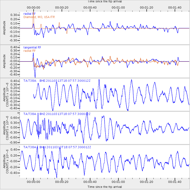
T38A Diamond, MO, USA - Earthquake Result Viewer
*The percent match for this event was below the threshold and hence no stack was calculated.
| Earthquake location: |
Near East Coast Of Honshu, Japan |
| Earthquake latitude/longitude: |
35.2/141.1 |
| Earthquake time(UTC): |
2011/03/13 (072) 17:55:21 GMT |
| Earthquake Depth: |
9.6 km |
| Earthquake Magnitude: |
5.5 MB, 5.3 MS, 5.7 MW, 5.6 MW |
| Earthquake Catalog/Contributor: |
WHDF/NEIC |
|
| Network: |
TA USArray Transportable Network (new EarthScope stations) |
| Station: |
T38A Diamond, MO, USA |
| Lat/Lon: |
37.04 N/94.29 W |
| Elevation: |
349 m |
|
| Distance: |
91.6 deg |
| Az: |
41.215 deg |
| Baz: |
317.567 deg |
| Ray Param: |
$rayparam |
*The percent match for this event was below the threshold and hence was not used in the summary stack. |
|
| Radial Match: |
39.886757 % |
| Radial Bump: |
400 |
| Transverse Match: |
72.38394 % |
| Transverse Bump: |
400 |
| SOD ConfigId: |
356183 |
| Insert Time: |
2011-08-20 21:56:32.572 +0000 |
| GWidth: |
2.5 |
| Max Bumps: |
400 |
| Tol: |
0.001 |
|
Signal To Noise
| Channel | StoN | STA | LTA |
| TA:T38A: :BHZ:20110313T18:07:57.300012Z | 0.97045237 | 3.363471E-7 | 3.4658797E-7 |
| TA:T38A: :BHN:20110313T18:07:57.300012Z | 1.2076923 | 2.7735143E-7 | 2.2965405E-7 |
| TA:T38A: :BHE:20110313T18:07:57.300012Z | 1.0888087 | 2.1828637E-7 | 2.0048186E-7 |
| Arrivals |
| Ps | |
| PpPs | |
| PsPs/PpSs | |


