You are here: Home > Network List > TA - USArray Transportable Network (new EarthScope stations) Stations List
> Station H17A Grant Village (NPS), Yellowstone Nt. Park, WY, USA > Earthquake Result Viewer
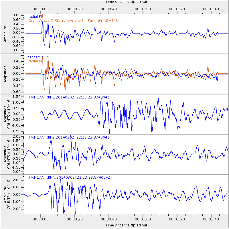
H17A Grant Village (NPS), Yellowstone Nt. Park, WY, USA - Earthquake Result Viewer
*The percent match for this event was below the threshold and hence no stack was calculated.
| Earthquake location: |
Near Coast Of Chiapas, Mexico |
| Earthquake latitude/longitude: |
14.2/-93.2 |
| Earthquake time(UTC): |
2014/03/02 (061) 22:17:14 GMT |
| Earthquake Depth: |
20 km |
| Earthquake Magnitude: |
6.0 MWC, 6.0 MWC, 6.0 MWW |
| Earthquake Catalog/Contributor: |
NEIC PDE/NEIC COMCAT |
|
| Network: |
TA USArray Transportable Network (new EarthScope stations) |
| Station: |
H17A Grant Village (NPS), Yellowstone Nt. Park, WY, USA |
| Lat/Lon: |
44.40 N/110.58 W |
| Elevation: |
2400 m |
|
| Distance: |
33.6 deg |
| Az: |
337.147 deg |
| Baz: |
148.306 deg |
| Ray Param: |
$rayparam |
*The percent match for this event was below the threshold and hence was not used in the summary stack. |
|
| Radial Match: |
54.390514 % |
| Radial Bump: |
400 |
| Transverse Match: |
79.07335 % |
| Transverse Bump: |
400 |
| SOD ConfigId: |
3390531 |
| Insert Time: |
2019-04-10 12:09:17.579 +0000 |
| GWidth: |
2.5 |
| Max Bumps: |
400 |
| Tol: |
0.001 |
|
Signal To Noise
| Channel | StoN | STA | LTA |
| TA:H17A: :BHZ:20140302T22:23:23.874004Z | 0.59231985 | 1.6161658E-7 | 2.7285355E-7 |
| TA:H17A: :BHN:20140302T22:23:23.874004Z | 1.3730633 | 2.4493787E-7 | 1.7838788E-7 |
| TA:H17A: :BHE:20140302T22:23:23.874004Z | 0.7509669 | 1.7653237E-7 | 2.3507344E-7 |
| Arrivals |
| Ps | |
| PpPs | |
| PsPs/PpSs | |


