You are here: Home > Network List > TA - USArray Transportable Network (new EarthScope stations) Stations List
> Station C36A Pine Crest Fram, Angora, MN, USA > Earthquake Result Viewer
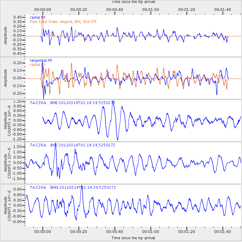
C36A Pine Crest Fram, Angora, MN, USA - Earthquake Result Viewer
*The percent match for this event was below the threshold and hence no stack was calculated.
| Earthquake location: |
Near East Coast Of Honshu, Japan |
| Earthquake latitude/longitude: |
36.4/140.9 |
| Earthquake time(UTC): |
2011/03/14 (073) 01:02:38 GMT |
| Earthquake Depth: |
11 km |
| Earthquake Magnitude: |
6.0 MB, 5.6 MS, 5.7 MW, 5.5 MW |
| Earthquake Catalog/Contributor: |
WHDF/NEIC |
|
| Network: |
TA USArray Transportable Network (new EarthScope stations) |
| Station: |
C36A Pine Crest Fram, Angora, MN, USA |
| Lat/Lon: |
47.76 N/92.84 W |
| Elevation: |
410 m |
|
| Distance: |
83.4 deg |
| Az: |
33.202 deg |
| Baz: |
319.103 deg |
| Ray Param: |
$rayparam |
*The percent match for this event was below the threshold and hence was not used in the summary stack. |
|
| Radial Match: |
44.333763 % |
| Radial Bump: |
400 |
| Transverse Match: |
67.20662 % |
| Transverse Bump: |
400 |
| SOD ConfigId: |
356183 |
| Insert Time: |
2011-08-20 22:42:04.587 +0000 |
| GWidth: |
2.5 |
| Max Bumps: |
400 |
| Tol: |
0.001 |
|
Signal To Noise
| Channel | StoN | STA | LTA |
| TA:C36A: :BHZ:20110314T01:14:34.525027Z | 1.4609863 | 4.6778322E-7 | 3.2018318E-7 |
| TA:C36A: :BHN:20110314T01:14:34.525027Z | 1.2137754 | 3.9547552E-7 | 3.2582267E-7 |
| TA:C36A: :BHE:20110314T01:14:34.525027Z | 2.1862361 | 5.609914E-7 | 2.5660145E-7 |
| Arrivals |
| Ps | |
| PpPs | |
| PsPs/PpSs | |


