You are here: Home > Network List > TA - USArray Transportable Network (new EarthScope stations) Stations List
> Station 242A Grayson, LA, USA > Earthquake Result Viewer
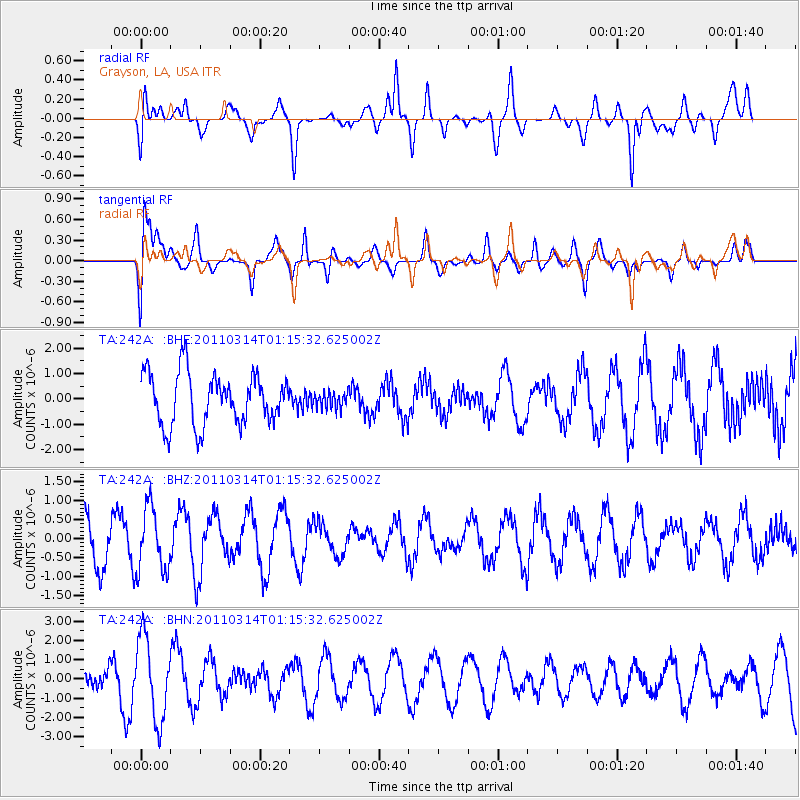
242A Grayson, LA, USA - Earthquake Result Viewer
*The percent match for this event was below the threshold and hence no stack was calculated.
| Earthquake location: |
Near East Coast Of Honshu, Japan |
| Earthquake latitude/longitude: |
36.4/140.9 |
| Earthquake time(UTC): |
2011/03/14 (073) 01:02:38 GMT |
| Earthquake Depth: |
11 km |
| Earthquake Magnitude: |
6.0 MB, 5.6 MS, 5.7 MW, 5.5 MW |
| Earthquake Catalog/Contributor: |
WHDF/NEIC |
|
| Network: |
TA USArray Transportable Network (new EarthScope stations) |
| Station: |
242A Grayson, LA, USA |
| Lat/Lon: |
32.06 N/92.15 W |
| Elevation: |
57 m |
|
| Distance: |
95.7 deg |
| Az: |
42.992 deg |
| Baz: |
319.618 deg |
| Ray Param: |
$rayparam |
*The percent match for this event was below the threshold and hence was not used in the summary stack. |
|
| Radial Match: |
57.73151 % |
| Radial Bump: |
400 |
| Transverse Match: |
49.135456 % |
| Transverse Bump: |
400 |
| SOD ConfigId: |
356183 |
| Insert Time: |
2011-08-20 22:44:19.541 +0000 |
| GWidth: |
2.5 |
| Max Bumps: |
400 |
| Tol: |
0.001 |
|
Signal To Noise
| Channel | StoN | STA | LTA |
| TA:242A: :BHZ:20110314T01:15:32.625002Z | 1.9877589 | 8.323196E-7 | 4.187226E-7 |
| TA:242A: :BHN:20110314T01:15:32.625002Z | 4.7706294 | 2.1297556E-6 | 4.464307E-7 |
| TA:242A: :BHE:20110314T01:15:32.625002Z | 0.30520305 | 3.0639134E-7 | 1.0038934E-6 |
| Arrivals |
| Ps | |
| PpPs | |
| PsPs/PpSs | |


