You are here: Home > Network List > TA - USArray Transportable Network (new EarthScope stations) Stations List
> Station H28A Mission Ridge, SD, USA > Earthquake Result Viewer
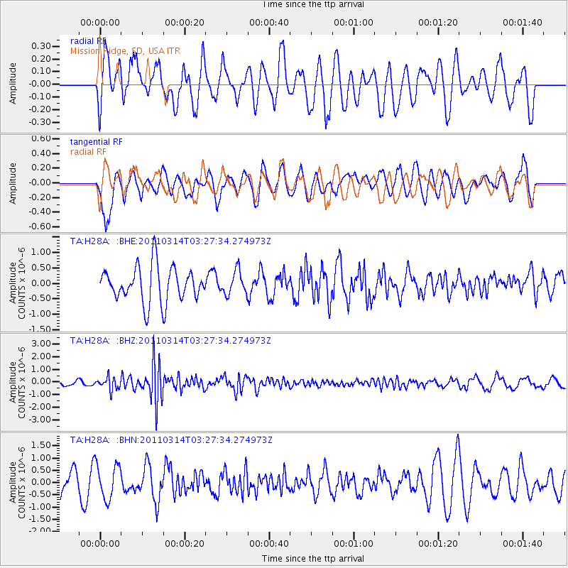
H28A Mission Ridge, SD, USA - Earthquake Result Viewer
*The percent match for this event was below the threshold and hence no stack was calculated.
| Earthquake location: |
Off East Coast Of Honshu, Japan |
| Earthquake latitude/longitude: |
36.3/142.1 |
| Earthquake time(UTC): |
2011/03/14 (073) 03:15:50 GMT |
| Earthquake Depth: |
16 km |
| Earthquake Magnitude: |
5.7 MB, 5.0 MS, 5.4 MW, 5.4 MW |
| Earthquake Catalog/Contributor: |
WHDF/NEIC |
|
| Network: |
TA USArray Transportable Network (new EarthScope stations) |
| Station: |
H28A Mission Ridge, SD, USA |
| Lat/Lon: |
44.68 N/101.02 W |
| Elevation: |
642 m |
|
| Distance: |
81.3 deg |
| Az: |
40.071 deg |
| Baz: |
313.191 deg |
| Ray Param: |
$rayparam |
*The percent match for this event was below the threshold and hence was not used in the summary stack. |
|
| Radial Match: |
54.20899 % |
| Radial Bump: |
400 |
| Transverse Match: |
59.819828 % |
| Transverse Bump: |
400 |
| SOD ConfigId: |
356183 |
| Insert Time: |
2011-08-20 23:14:51.068 +0000 |
| GWidth: |
2.5 |
| Max Bumps: |
400 |
| Tol: |
0.001 |
|
Signal To Noise
| Channel | StoN | STA | LTA |
| TA:H28A: :BHZ:20110314T03:27:34.274973Z | 1.9861743 | 4.918052E-7 | 2.4761434E-7 |
| TA:H28A: :BHN:20110314T03:27:34.274973Z | 0.9058969 | 6.863191E-7 | 7.576128E-7 |
| TA:H28A: :BHE:20110314T03:27:34.274973Z | 0.6900112 | 3.9753084E-7 | 5.761223E-7 |
| Arrivals |
| Ps | |
| PpPs | |
| PsPs/PpSs | |


