You are here: Home > Network List > AV - Alaska Volcano Observatory Stations List
> Station SPCR Ckakachatna River, Mount Spurr, Alaska > Earthquake Result Viewer
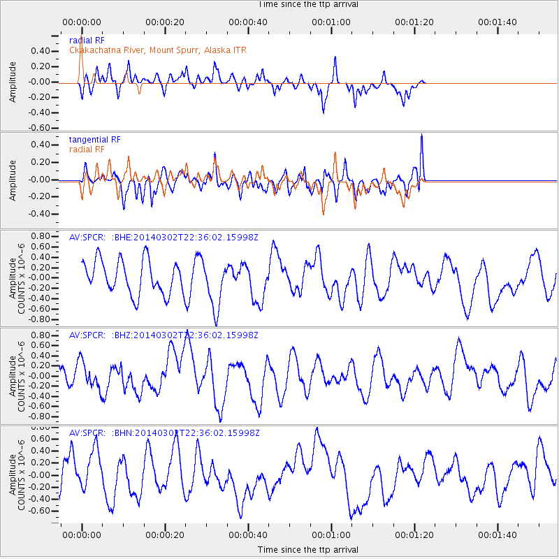
SPCR Ckakachatna River, Mount Spurr, Alaska - Earthquake Result Viewer
*The percent match for this event was below the threshold and hence no stack was calculated.
| Earthquake location: |
Near Coast Of Chiapas, Mexico |
| Earthquake latitude/longitude: |
14.2/-93.1 |
| Earthquake time(UTC): |
2014/03/02 (061) 22:26:10 GMT |
| Earthquake Depth: |
36 km |
| Earthquake Magnitude: |
5.4 MW |
| Earthquake Catalog/Contributor: |
ISC/ISC |
|
| Network: |
AV Alaska Volcano Observatory |
| Station: |
SPCR Ckakachatna River, Mount Spurr, Alaska |
| Lat/Lon: |
61.20 N/152.21 W |
| Elevation: |
984 m |
|
| Distance: |
62.9 deg |
| Az: |
332.189 deg |
| Baz: |
110.886 deg |
| Ray Param: |
$rayparam |
*The percent match for this event was below the threshold and hence was not used in the summary stack. |
|
| Radial Match: |
55.42646 % |
| Radial Bump: |
326 |
| Transverse Match: |
54.99629 % |
| Transverse Bump: |
400 |
| SOD ConfigId: |
3390531 |
| Insert Time: |
2019-04-10 12:11:39.805 +0000 |
| GWidth: |
2.5 |
| Max Bumps: |
400 |
| Tol: |
0.001 |
|
Signal To Noise
| Channel | StoN | STA | LTA |
| AV:SPCR: :BHZ:20140302T22:36:02.15998Z | 1.3934622 | 2.6778392E-7 | 1.9217165E-7 |
| AV:SPCR: :BHN:20140302T22:36:02.15998Z | 1.1504585 | 3.5309813E-7 | 3.0691953E-7 |
| AV:SPCR: :BHE:20140302T22:36:02.15998Z | 1.4614005 | 4.6709982E-7 | 3.1962477E-7 |
| Arrivals |
| Ps | |
| PpPs | |
| PsPs/PpSs | |


