You are here: Home > Network List > TA - USArray Transportable Network (new EarthScope stations) Stations List
> Station 533A Kerrville, TX, USA > Earthquake Result Viewer
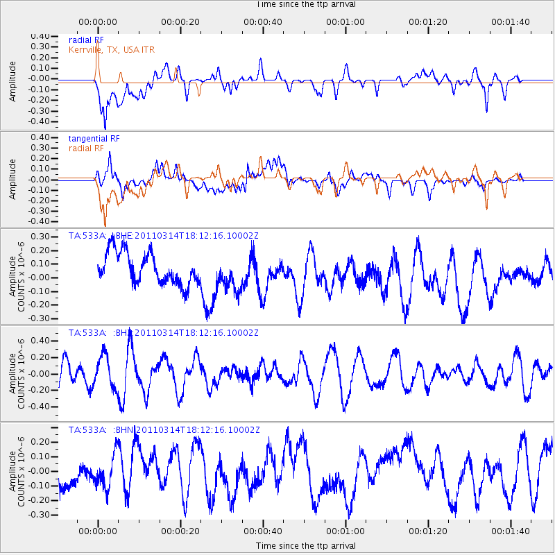
533A Kerrville, TX, USA - Earthquake Result Viewer
*The percent match for this event was below the threshold and hence no stack was calculated.
| Earthquake location: |
Off East Coast Of Honshu, Japan |
| Earthquake latitude/longitude: |
37.2/142.2 |
| Earthquake time(UTC): |
2011/03/14 (073) 17:59:41 GMT |
| Earthquake Depth: |
20 km |
| Earthquake Magnitude: |
5.7 MW, 5.4 MS, 5.4 MB, 5.6 MW |
| Earthquake Catalog/Contributor: |
WHDF/NEIC |
|
| Network: |
TA USArray Transportable Network (new EarthScope stations) |
| Station: |
533A Kerrville, TX, USA |
| Lat/Lon: |
30.07 N/99.04 W |
| Elevation: |
556 m |
|
| Distance: |
91.9 deg |
| Az: |
49.518 deg |
| Baz: |
315.528 deg |
| Ray Param: |
$rayparam |
*The percent match for this event was below the threshold and hence was not used in the summary stack. |
|
| Radial Match: |
54.561375 % |
| Radial Bump: |
400 |
| Transverse Match: |
45.798054 % |
| Transverse Bump: |
400 |
| SOD ConfigId: |
356183 |
| Insert Time: |
2011-08-21 00:07:42.387 +0000 |
| GWidth: |
2.5 |
| Max Bumps: |
400 |
| Tol: |
0.001 |
|
Signal To Noise
| Channel | StoN | STA | LTA |
| TA:533A: :BHZ:20110314T18:12:16.10002Z | 1.4900773 | 1.9834407E-7 | 1.3310994E-7 |
| TA:533A: :BHN:20110314T18:12:16.10002Z | 1.2063484 | 1.1549119E-7 | 9.573618E-8 |
| TA:533A: :BHE:20110314T18:12:16.10002Z | 1.1146178 | 1.2829695E-7 | 1.1510398E-7 |
| Arrivals |
| Ps | |
| PpPs | |
| PsPs/PpSs | |


