You are here: Home > Network List > TA - USArray Transportable Network (new EarthScope stations) Stations List
> Station G59A Clarenceville, QC, USA > Earthquake Result Viewer
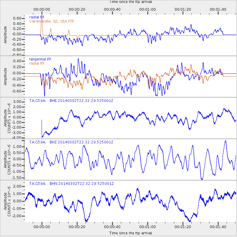
G59A Clarenceville, QC, USA - Earthquake Result Viewer
*The percent match for this event was below the threshold and hence no stack was calculated.
| Earthquake location: |
Near Coast Of Chiapas, Mexico |
| Earthquake latitude/longitude: |
14.2/-93.1 |
| Earthquake time(UTC): |
2014/03/02 (061) 22:26:10 GMT |
| Earthquake Depth: |
36 km |
| Earthquake Magnitude: |
5.4 MW |
| Earthquake Catalog/Contributor: |
ISC/ISC |
|
| Network: |
TA USArray Transportable Network (new EarthScope stations) |
| Station: |
G59A Clarenceville, QC, USA |
| Lat/Lon: |
45.08 N/73.18 W |
| Elevation: |
36 m |
|
| Distance: |
35.1 deg |
| Az: |
24.85 deg |
| Baz: |
215.113 deg |
| Ray Param: |
$rayparam |
*The percent match for this event was below the threshold and hence was not used in the summary stack. |
|
| Radial Match: |
54.78386 % |
| Radial Bump: |
400 |
| Transverse Match: |
67.76332 % |
| Transverse Bump: |
400 |
| SOD ConfigId: |
3390531 |
| Insert Time: |
2019-04-10 12:14:14.655 +0000 |
| GWidth: |
2.5 |
| Max Bumps: |
400 |
| Tol: |
0.001 |
|
Signal To Noise
| Channel | StoN | STA | LTA |
| TA:G59A: :BHZ:20140302T22:32:29.525001Z | 1.0418031 | 3.848081E-7 | 3.693674E-7 |
| TA:G59A: :BHN:20140302T22:32:29.525001Z | 0.95821625 | 7.018941E-7 | 7.325008E-7 |
| TA:G59A: :BHE:20140302T22:32:29.525001Z | 1.254548 | 1.7880101E-6 | 1.4252226E-6 |
| Arrivals |
| Ps | |
| PpPs | |
| PsPs/PpSs | |


