You are here: Home > Network List > KN - Kyrgyz Seismic Telemetry Network Stations List
> Station TKM2 KN.TKM2 > Earthquake Result Viewer
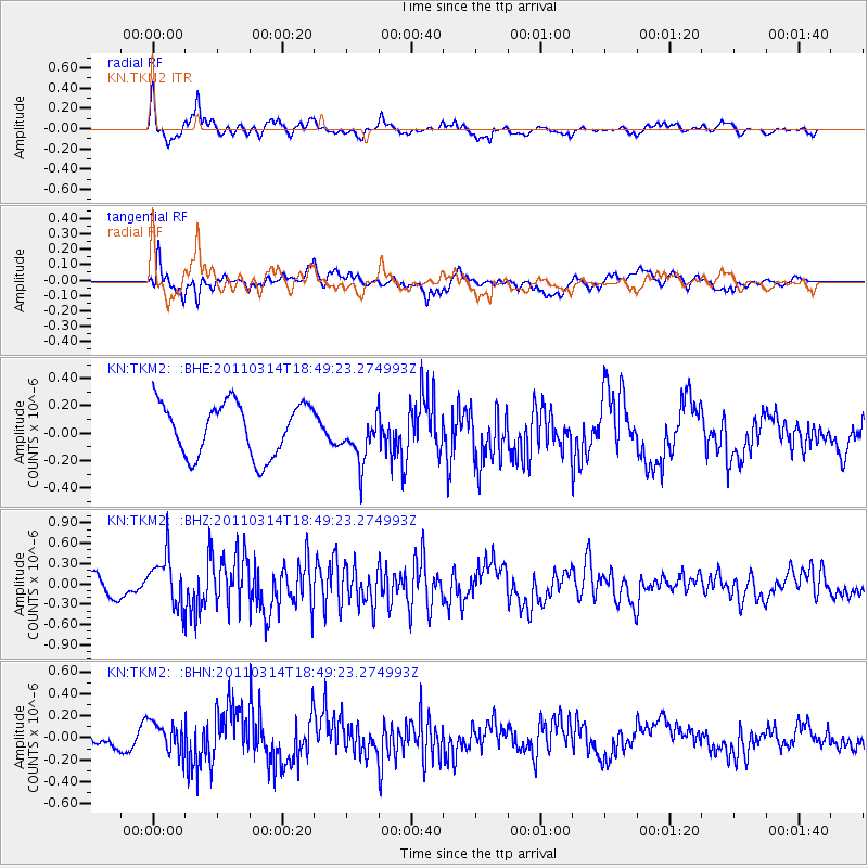
TKM2 KN.TKM2 - Earthquake Result Viewer
*The percent match for this event was below the threshold and hence no stack was calculated.
| Earthquake location: |
Near East Coast Of Honshu, Japan |
| Earthquake latitude/longitude: |
36.6/141.7 |
| Earthquake time(UTC): |
2011/03/14 (073) 18:41:01 GMT |
| Earthquake Depth: |
26 km |
| Earthquake Magnitude: |
5.6 MB, 5.4 MW |
| Earthquake Catalog/Contributor: |
WHDF/NEIC |
|
| Network: |
KN Kyrgyz Seismic Telemetry Network |
| Station: |
TKM2 KN.TKM2 |
| Lat/Lon: |
42.92 N/75.60 E |
| Elevation: |
2020 m |
|
| Distance: |
50.1 deg |
| Az: |
298.841 deg |
| Baz: |
73.724 deg |
| Ray Param: |
$rayparam |
*The percent match for this event was below the threshold and hence was not used in the summary stack. |
|
| Radial Match: |
73.13489 % |
| Radial Bump: |
385 |
| Transverse Match: |
64.47623 % |
| Transverse Bump: |
400 |
| SOD ConfigId: |
356183 |
| Insert Time: |
2011-08-21 00:29:45.328 +0000 |
| GWidth: |
2.5 |
| Max Bumps: |
400 |
| Tol: |
0.001 |
|
Signal To Noise
| Channel | StoN | STA | LTA |
| KN:TKM2: :BHZ:20110314T18:49:23.274993Z | 2.1191406 | 3.7588367E-7 | 1.7737553E-7 |
| KN:TKM2: :BHN:20110314T18:49:23.274993Z | 1.604753 | 1.4590675E-7 | 9.0921624E-8 |
| KN:TKM2: :BHE:20110314T18:49:23.274993Z | 0.93608767 | 1.7850373E-7 | 1.9069124E-7 |
| Arrivals |
| Ps | |
| PpPs | |
| PsPs/PpSs | |


