You are here: Home > Network List > TA - USArray Transportable Network (new EarthScope stations) Stations List
> Station E36A McGregor, MN, USA > Earthquake Result Viewer
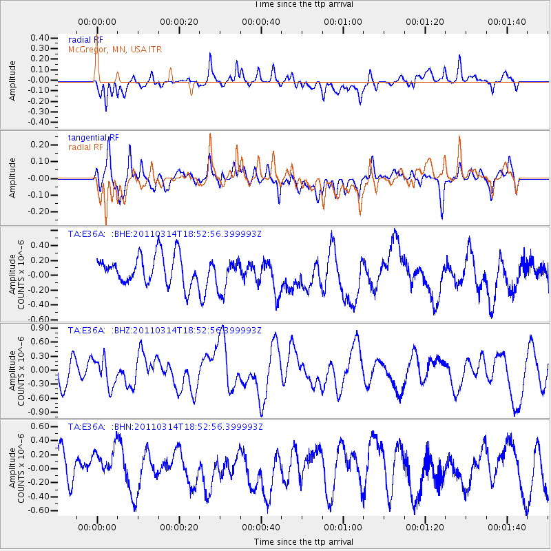
E36A McGregor, MN, USA - Earthquake Result Viewer
*The percent match for this event was below the threshold and hence no stack was calculated.
| Earthquake location: |
Near East Coast Of Honshu, Japan |
| Earthquake latitude/longitude: |
36.6/141.7 |
| Earthquake time(UTC): |
2011/03/14 (073) 18:41:01 GMT |
| Earthquake Depth: |
26 km |
| Earthquake Magnitude: |
5.6 MB, 5.4 MW |
| Earthquake Catalog/Contributor: |
WHDF/NEIC |
|
| Network: |
TA USArray Transportable Network (new EarthScope stations) |
| Station: |
E36A McGregor, MN, USA |
| Lat/Lon: |
46.52 N/93.26 W |
| Elevation: |
393 m |
|
| Distance: |
83.7 deg |
| Az: |
34.691 deg |
| Baz: |
318.436 deg |
| Ray Param: |
$rayparam |
*The percent match for this event was below the threshold and hence was not used in the summary stack. |
|
| Radial Match: |
54.54334 % |
| Radial Bump: |
400 |
| Transverse Match: |
56.74219 % |
| Transverse Bump: |
400 |
| SOD ConfigId: |
356183 |
| Insert Time: |
2011-08-21 00:45:50.914 +0000 |
| GWidth: |
2.5 |
| Max Bumps: |
400 |
| Tol: |
0.001 |
|
Signal To Noise
| Channel | StoN | STA | LTA |
| TA:E36A: :BHZ:20110314T18:52:56.399993Z | 0.7691311 | 2.978083E-7 | 3.8720094E-7 |
| TA:E36A: :BHN:20110314T18:52:56.399993Z | 1.3293043 | 3.3111135E-7 | 2.4908618E-7 |
| TA:E36A: :BHE:20110314T18:52:56.399993Z | 1.1324122 | 2.2069194E-7 | 1.9488658E-7 |
| Arrivals |
| Ps | |
| PpPs | |
| PsPs/PpSs | |


