You are here: Home > Network List > UW - Pacific Northwest Regional Seismic Network Stations List
> Station HOOD Mt Hood Meadows, OR CREST BB SMO > Earthquake Result Viewer
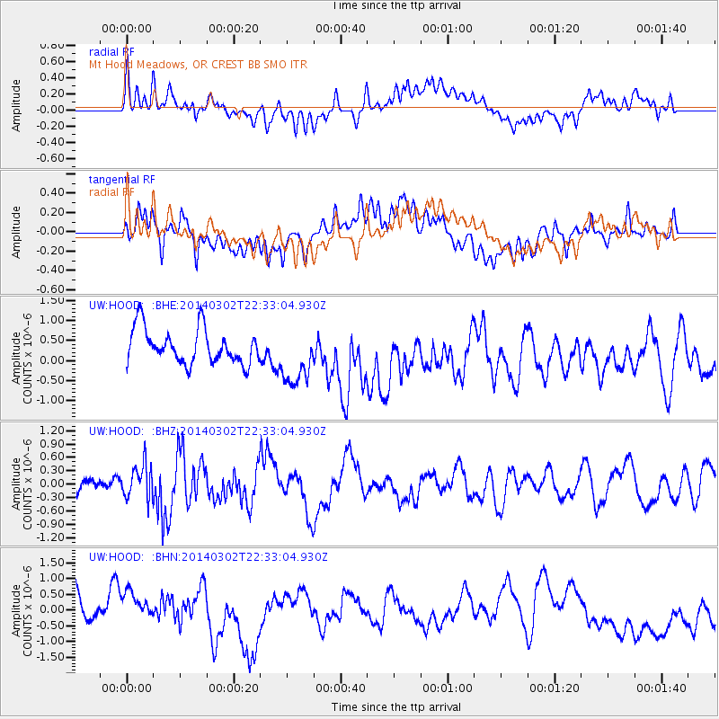
HOOD Mt Hood Meadows, OR CREST BB SMO - Earthquake Result Viewer
*The percent match for this event was below the threshold and hence no stack was calculated.
| Earthquake location: |
Near Coast Of Chiapas, Mexico |
| Earthquake latitude/longitude: |
14.2/-93.1 |
| Earthquake time(UTC): |
2014/03/02 (061) 22:26:10 GMT |
| Earthquake Depth: |
36 km |
| Earthquake Magnitude: |
5.4 MW |
| Earthquake Catalog/Contributor: |
ISC/ISC |
|
| Network: |
UW Pacific Northwest Regional Seismic Network |
| Station: |
HOOD Mt Hood Meadows, OR CREST BB SMO |
| Lat/Lon: |
45.32 N/121.65 W |
| Elevation: |
1520 m |
|
| Distance: |
39.3 deg |
| Az: |
327.827 deg |
| Baz: |
132.958 deg |
| Ray Param: |
$rayparam |
*The percent match for this event was below the threshold and hence was not used in the summary stack. |
|
| Radial Match: |
37.91092 % |
| Radial Bump: |
400 |
| Transverse Match: |
58.61423 % |
| Transverse Bump: |
400 |
| SOD ConfigId: |
3390531 |
| Insert Time: |
2019-04-10 12:15:05.386 +0000 |
| GWidth: |
2.5 |
| Max Bumps: |
400 |
| Tol: |
0.001 |
|
Signal To Noise
| Channel | StoN | STA | LTA |
| UW:HOOD: :BHZ:20140302T22:33:04.930Z | 1.5633754 | 3.8814133E-7 | 2.4827136E-7 |
| UW:HOOD: :BHN:20140302T22:33:04.930Z | 1.0643836 | 6.18448E-7 | 5.810386E-7 |
| UW:HOOD: :BHE:20140302T22:33:04.930Z | 1.6723845 | 7.244124E-7 | 4.331614E-7 |
| Arrivals |
| Ps | |
| PpPs | |
| PsPs/PpSs | |


