You are here: Home > Network List > MN - MEDNET Project Stations List
> Station TIP Timpagrande, Italy > Earthquake Result Viewer
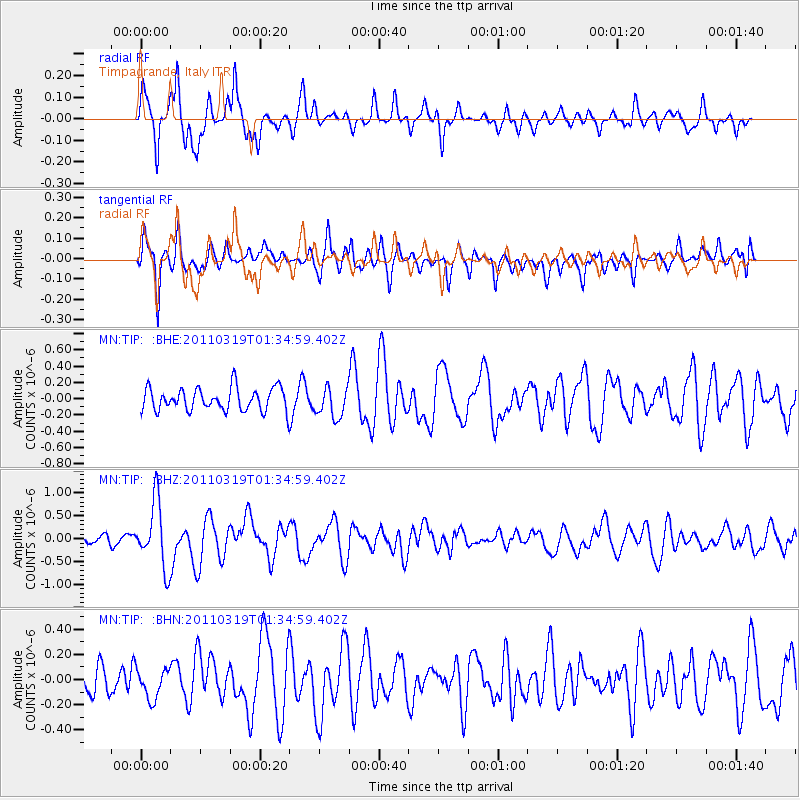
TIP Timpagrande, Italy - Earthquake Result Viewer
*The percent match for this event was below the threshold and hence no stack was calculated.
| Earthquake location: |
Near East Coast Of Honshu, Japan |
| Earthquake latitude/longitude: |
39.7/142.9 |
| Earthquake time(UTC): |
2011/03/19 (078) 01:22:44 GMT |
| Earthquake Depth: |
15 km |
| Earthquake Magnitude: |
5.8 MB, 5.6 MS, 5.9 MW, 5.9 MW |
| Earthquake Catalog/Contributor: |
WHDF/NEIC |
|
| Network: |
MN MEDNET Project |
| Station: |
TIP Timpagrande, Italy |
| Lat/Lon: |
39.18 N/16.76 E |
| Elevation: |
789 m |
|
| Distance: |
87.3 deg |
| Az: |
321.074 deg |
| Baz: |
38.588 deg |
| Ray Param: |
$rayparam |
*The percent match for this event was below the threshold and hence was not used in the summary stack. |
|
| Radial Match: |
77.84211 % |
| Radial Bump: |
289 |
| Transverse Match: |
69.766136 % |
| Transverse Bump: |
394 |
| SOD ConfigId: |
356183 |
| Insert Time: |
2011-08-21 03:09:34.998 +0000 |
| GWidth: |
2.5 |
| Max Bumps: |
400 |
| Tol: |
0.001 |
|
Signal To Noise
| Channel | StoN | STA | LTA |
| MN:TIP: :BHZ:20110319T01:34:59.402Z | 6.6238794 | 7.214039E-7 | 1.0890958E-7 |
| MN:TIP: :BHN:20110319T01:34:59.402Z | 0.9704063 | 1.1477719E-7 | 1.1827746E-7 |
| MN:TIP: :BHE:20110319T01:34:59.402Z | 1.325608 | 1.8461658E-7 | 1.3926936E-7 |
| Arrivals |
| Ps | |
| PpPs | |
| PsPs/PpSs | |


