You are here: Home > Network List > TA - USArray Transportable Network (new EarthScope stations) Stations List
> Station X33A Lawton, OK, USA > Earthquake Result Viewer
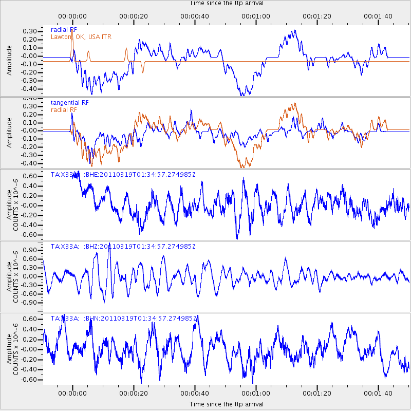
X33A Lawton, OK, USA - Earthquake Result Viewer
*The percent match for this event was below the threshold and hence no stack was calculated.
| Earthquake location: |
Near East Coast Of Honshu, Japan |
| Earthquake latitude/longitude: |
39.7/142.9 |
| Earthquake time(UTC): |
2011/03/19 (078) 01:22:44 GMT |
| Earthquake Depth: |
15 km |
| Earthquake Magnitude: |
5.8 MB, 5.6 MS, 5.9 MW, 5.9 MW |
| Earthquake Catalog/Contributor: |
WHDF/NEIC |
|
| Network: |
TA USArray Transportable Network (new EarthScope stations) |
| Station: |
X33A Lawton, OK, USA |
| Lat/Lon: |
34.54 N/98.50 W |
| Elevation: |
346 m |
|
| Distance: |
86.9 deg |
| Az: |
46.541 deg |
| Baz: |
317.279 deg |
| Ray Param: |
$rayparam |
*The percent match for this event was below the threshold and hence was not used in the summary stack. |
|
| Radial Match: |
30.723457 % |
| Radial Bump: |
400 |
| Transverse Match: |
43.877007 % |
| Transverse Bump: |
400 |
| SOD ConfigId: |
356183 |
| Insert Time: |
2011-08-21 03:26:08.916 +0000 |
| GWidth: |
2.5 |
| Max Bumps: |
400 |
| Tol: |
0.001 |
|
Signal To Noise
| Channel | StoN | STA | LTA |
| TA:X33A: :BHZ:20110319T01:34:57.274985Z | 1.0200365 | 2.3989182E-7 | 2.3517967E-7 |
| TA:X33A: :BHN:20110319T01:34:57.274985Z | 0.7850376 | 4.2961116E-7 | 5.4724916E-7 |
| TA:X33A: :BHE:20110319T01:34:57.274985Z | 0.92229027 | 2.7788104E-7 | 3.0129456E-7 |
| Arrivals |
| Ps | |
| PpPs | |
| PsPs/PpSs | |


