You are here: Home > Network List > TA - USArray Transportable Network (new EarthScope stations) Stations List
> Station N34A Lincoln, NE, USA > Earthquake Result Viewer
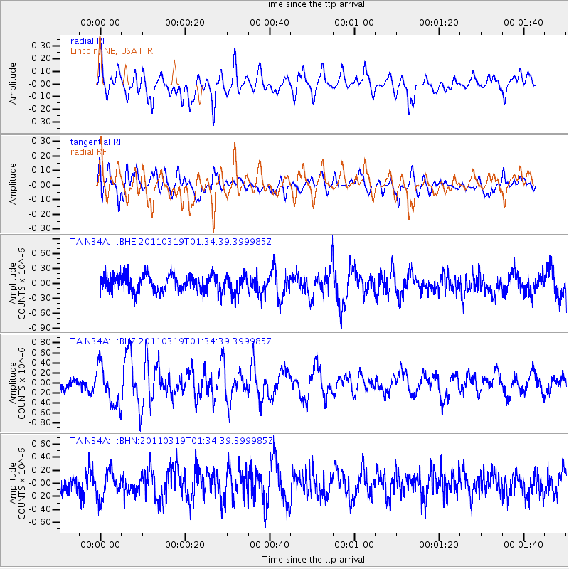
N34A Lincoln, NE, USA - Earthquake Result Viewer
*The percent match for this event was below the threshold and hence no stack was calculated.
| Earthquake location: |
Near East Coast Of Honshu, Japan |
| Earthquake latitude/longitude: |
39.7/142.9 |
| Earthquake time(UTC): |
2011/03/19 (078) 01:22:44 GMT |
| Earthquake Depth: |
15 km |
| Earthquake Magnitude: |
5.8 MB, 5.6 MS, 5.9 MW, 5.9 MW |
| Earthquake Catalog/Contributor: |
WHDF/NEIC |
|
| Network: |
TA USArray Transportable Network (new EarthScope stations) |
| Station: |
N34A Lincoln, NE, USA |
| Lat/Lon: |
40.84 N/96.50 W |
| Elevation: |
401 m |
|
| Distance: |
83.3 deg |
| Az: |
41.115 deg |
| Baz: |
318.034 deg |
| Ray Param: |
$rayparam |
*The percent match for this event was below the threshold and hence was not used in the summary stack. |
|
| Radial Match: |
69.30975 % |
| Radial Bump: |
400 |
| Transverse Match: |
51.997456 % |
| Transverse Bump: |
400 |
| SOD ConfigId: |
356183 |
| Insert Time: |
2011-08-21 03:28:20.937 +0000 |
| GWidth: |
2.5 |
| Max Bumps: |
400 |
| Tol: |
0.001 |
|
Signal To Noise
| Channel | StoN | STA | LTA |
| TA:N34A: :BHZ:20110319T01:34:39.399985Z | 2.8913212 | 3.8898813E-7 | 1.3453646E-7 |
| TA:N34A: :BHN:20110319T01:34:39.399985Z | 1.1611466 | 2.0649577E-7 | 1.778378E-7 |
| TA:N34A: :BHE:20110319T01:34:39.399985Z | 1.0995419 | 1.7485054E-7 | 1.5902125E-7 |
| Arrivals |
| Ps | |
| PpPs | |
| PsPs/PpSs | |


