You are here: Home > Network List > TA - USArray Transportable Network (new EarthScope stations) Stations List
> Station C38A Sawbill Landing (USFS), Superior Nat. Forest, MN, > Earthquake Result Viewer
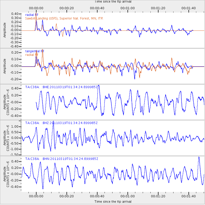
C38A Sawbill Landing (USFS), Superior Nat. Forest, MN, - Earthquake Result Viewer
*The percent match for this event was below the threshold and hence no stack was calculated.
| Earthquake location: |
Near East Coast Of Honshu, Japan |
| Earthquake latitude/longitude: |
39.7/142.9 |
| Earthquake time(UTC): |
2011/03/19 (078) 01:22:44 GMT |
| Earthquake Depth: |
15 km |
| Earthquake Magnitude: |
5.8 MB, 5.6 MS, 5.9 MW, 5.9 MW |
| Earthquake Catalog/Contributor: |
WHDF/NEIC |
|
| Network: |
TA USArray Transportable Network (new EarthScope stations) |
| Station: |
C38A Sawbill Landing (USFS), Superior Nat. Forest, MN, |
| Lat/Lon: |
47.72 N/91.27 W |
| Elevation: |
498 m |
|
| Distance: |
80.5 deg |
| Az: |
33.715 deg |
| Baz: |
320.638 deg |
| Ray Param: |
$rayparam |
*The percent match for this event was below the threshold and hence was not used in the summary stack. |
|
| Radial Match: |
57.919083 % |
| Radial Bump: |
304 |
| Transverse Match: |
56.870872 % |
| Transverse Bump: |
400 |
| SOD ConfigId: |
356183 |
| Insert Time: |
2011-08-21 03:34:10.962 +0000 |
| GWidth: |
2.5 |
| Max Bumps: |
400 |
| Tol: |
0.001 |
|
Signal To Noise
| Channel | StoN | STA | LTA |
| TA:C38A: :BHZ:20110319T01:34:24.899985Z | 2.7278621 | 5.5498765E-7 | 2.0345149E-7 |
| TA:C38A: :BHN:20110319T01:34:24.899985Z | 1.6970148 | 2.4991797E-7 | 1.4726918E-7 |
| TA:C38A: :BHE:20110319T01:34:24.899985Z | 0.57294947 | 9.892566E-8 | 1.7266036E-7 |
| Arrivals |
| Ps | |
| PpPs | |
| PsPs/PpSs | |


