You are here: Home > Network List > TA - USArray Transportable Network (new EarthScope stations) Stations List
> Station H26A Fairpoint, SD, USA > Earthquake Result Viewer
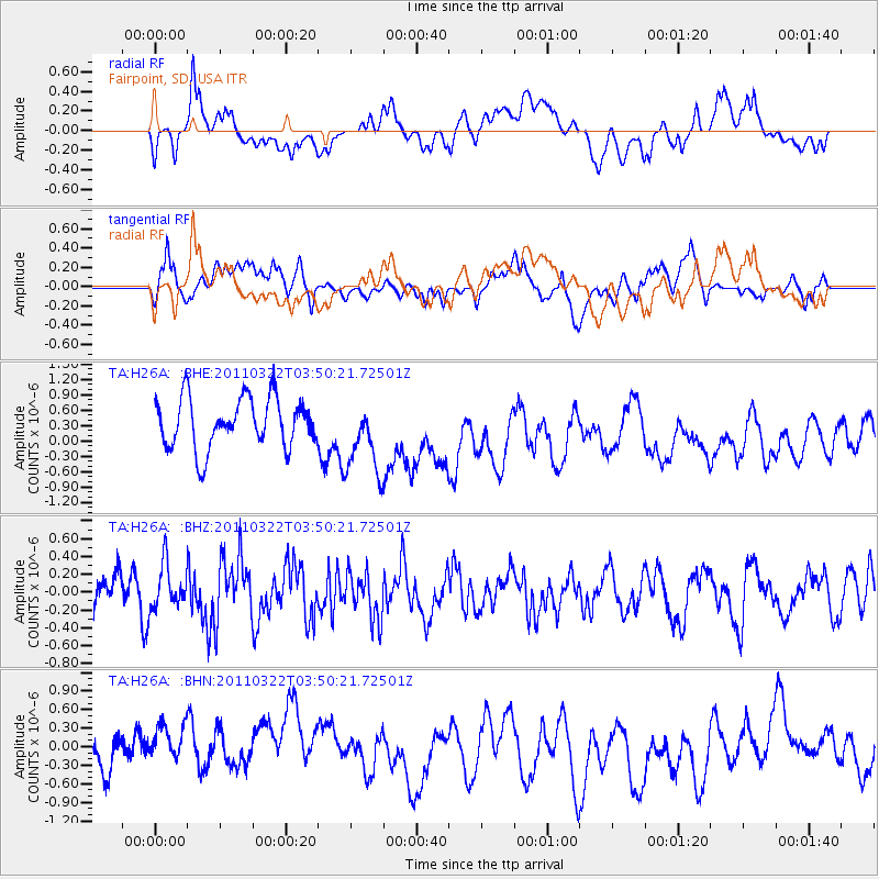
H26A Fairpoint, SD, USA - Earthquake Result Viewer
*The percent match for this event was below the threshold and hence no stack was calculated.
| Earthquake location: |
Near East Coast Of Honshu, Japan |
| Earthquake latitude/longitude: |
35.2/141.0 |
| Earthquake time(UTC): |
2011/03/22 (081) 03:38:35 GMT |
| Earthquake Depth: |
20 km |
| Earthquake Magnitude: |
5.5 MB, 5.4 MS, 5.7 MW, 5.6 MW |
| Earthquake Catalog/Contributor: |
WHDF/NEIC |
|
| Network: |
TA USArray Transportable Network (new EarthScope stations) |
| Station: |
H26A Fairpoint, SD, USA |
| Lat/Lon: |
44.62 N/102.77 W |
| Elevation: |
879 m |
|
| Distance: |
81.8 deg |
| Az: |
40.339 deg |
| Baz: |
312.077 deg |
| Ray Param: |
$rayparam |
*The percent match for this event was below the threshold and hence was not used in the summary stack. |
|
| Radial Match: |
41.536827 % |
| Radial Bump: |
400 |
| Transverse Match: |
52.58222 % |
| Transverse Bump: |
400 |
| SOD ConfigId: |
356183 |
| Insert Time: |
2011-08-21 04:43:10.759 +0000 |
| GWidth: |
2.5 |
| Max Bumps: |
400 |
| Tol: |
0.001 |
|
Signal To Noise
| Channel | StoN | STA | LTA |
| TA:H26A: :BHZ:20110322T03:50:21.72501Z | 1.0825018 | 2.46712E-7 | 2.2790911E-7 |
| TA:H26A: :BHN:20110322T03:50:21.72501Z | 1.2745038 | 3.827261E-7 | 3.0029423E-7 |
| TA:H26A: :BHE:20110322T03:50:21.72501Z | 1.4749371 | 7.208368E-7 | 4.887238E-7 |
| Arrivals |
| Ps | |
| PpPs | |
| PsPs/PpSs | |


