You are here: Home > Network List > TA - USArray Transportable Network (new EarthScope stations) Stations List
> Station W37B Quinton, OK, USA > Earthquake Result Viewer
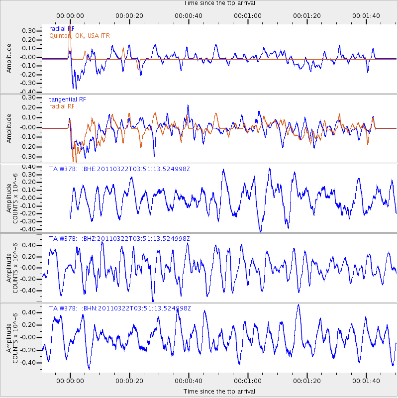
W37B Quinton, OK, USA - Earthquake Result Viewer
*The percent match for this event was below the threshold and hence no stack was calculated.
| Earthquake location: |
Near East Coast Of Honshu, Japan |
| Earthquake latitude/longitude: |
35.2/141.0 |
| Earthquake time(UTC): |
2011/03/22 (081) 03:38:35 GMT |
| Earthquake Depth: |
20 km |
| Earthquake Magnitude: |
5.5 MB, 5.4 MS, 5.7 MW, 5.6 MW |
| Earthquake Catalog/Contributor: |
WHDF/NEIC |
|
| Network: |
TA USArray Transportable Network (new EarthScope stations) |
| Station: |
W37B Quinton, OK, USA |
| Lat/Lon: |
35.14 N/95.43 W |
| Elevation: |
279 m |
|
| Distance: |
92.4 deg |
| Az: |
43.116 deg |
| Baz: |
316.927 deg |
| Ray Param: |
$rayparam |
*The percent match for this event was below the threshold and hence was not used in the summary stack. |
|
| Radial Match: |
55.849506 % |
| Radial Bump: |
400 |
| Transverse Match: |
54.04037 % |
| Transverse Bump: |
400 |
| SOD ConfigId: |
356183 |
| Insert Time: |
2011-08-21 04:59:40.508 +0000 |
| GWidth: |
2.5 |
| Max Bumps: |
400 |
| Tol: |
0.001 |
|
Signal To Noise
| Channel | StoN | STA | LTA |
| TA:W37B: :BHZ:20110322T03:51:13.524998Z | 1.3741009 | 2.0940912E-7 | 1.5239719E-7 |
| TA:W37B: :BHN:20110322T03:51:13.524998Z | 1.0270836 | 2.0558284E-7 | 2.0016172E-7 |
| TA:W37B: :BHE:20110322T03:51:13.524998Z | 0.71674913 | 9.9758836E-8 | 1.3918236E-7 |
| Arrivals |
| Ps | |
| PpPs | |
| PsPs/PpSs | |


