You are here: Home > Network List > TA - USArray Transportable Network (new EarthScope stations) Stations List
> Station H25A Fruitdale, SD, USA > Earthquake Result Viewer
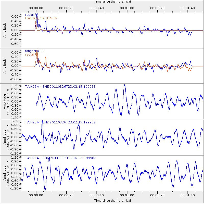
H25A Fruitdale, SD, USA - Earthquake Result Viewer
*The percent match for this event was below the threshold and hence no stack was calculated.
| Earthquake location: |
Fiji Islands Region |
| Earthquake latitude/longitude: |
-15.9/-179.4 |
| Earthquake time(UTC): |
2011/03/26 (085) 22:49:41 GMT |
| Earthquake Depth: |
10 km |
| Earthquake Magnitude: |
5.7 MB, 5.9 MS, 6.1 MW, 6.0 MW |
| Earthquake Catalog/Contributor: |
WHDF/NEIC |
|
| Network: |
TA USArray Transportable Network (new EarthScope stations) |
| Station: |
H25A Fruitdale, SD, USA |
| Lat/Lon: |
44.62 N/103.60 W |
| Elevation: |
942 m |
|
| Distance: |
91.2 deg |
| Az: |
43.827 deg |
| Baz: |
248.954 deg |
| Ray Param: |
$rayparam |
*The percent match for this event was below the threshold and hence was not used in the summary stack. |
|
| Radial Match: |
66.235916 % |
| Radial Bump: |
400 |
| Transverse Match: |
41.065926 % |
| Transverse Bump: |
389 |
| SOD ConfigId: |
356183 |
| Insert Time: |
2011-08-21 05:34:55.594 +0000 |
| GWidth: |
2.5 |
| Max Bumps: |
400 |
| Tol: |
0.001 |
|
Signal To Noise
| Channel | StoN | STA | LTA |
| TA:H25A: :BHZ:20110326T23:02:15.19998Z | 3.103689 | 4.9969674E-7 | 1.6100091E-7 |
| TA:H25A: :BHN:20110326T23:02:15.19998Z | 2.178016 | 6.043726E-7 | 2.774877E-7 |
| TA:H25A: :BHE:20110326T23:02:15.19998Z | 1.1233302 | 3.224549E-7 | 2.8705261E-7 |
| Arrivals |
| Ps | |
| PpPs | |
| PsPs/PpSs | |


