You are here: Home > Network List > TA - USArray Transportable Network (new EarthScope stations) Stations List
> Station G26A Maurine, SD, USA > Earthquake Result Viewer
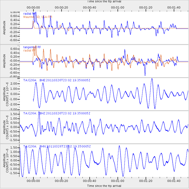
G26A Maurine, SD, USA - Earthquake Result Viewer
*The percent match for this event was below the threshold and hence no stack was calculated.
| Earthquake location: |
Fiji Islands Region |
| Earthquake latitude/longitude: |
-15.9/-179.4 |
| Earthquake time(UTC): |
2011/03/26 (085) 22:49:41 GMT |
| Earthquake Depth: |
10 km |
| Earthquake Magnitude: |
5.7 MB, 5.9 MS, 6.1 MW, 6.0 MW |
| Earthquake Catalog/Contributor: |
WHDF/NEIC |
|
| Network: |
TA USArray Transportable Network (new EarthScope stations) |
| Station: |
G26A Maurine, SD, USA |
| Lat/Lon: |
45.29 N/102.60 W |
| Elevation: |
833 m |
|
| Distance: |
92.1 deg |
| Az: |
43.449 deg |
| Baz: |
249.669 deg |
| Ray Param: |
$rayparam |
*The percent match for this event was below the threshold and hence was not used in the summary stack. |
|
| Radial Match: |
55.68851 % |
| Radial Bump: |
309 |
| Transverse Match: |
38.04576 % |
| Transverse Bump: |
298 |
| SOD ConfigId: |
356183 |
| Insert Time: |
2011-08-21 05:35:58.208 +0000 |
| GWidth: |
2.5 |
| Max Bumps: |
400 |
| Tol: |
0.001 |
|
Signal To Noise
| Channel | StoN | STA | LTA |
| TA:G26A: :BHZ:20110326T23:02:19.350005Z | 2.6837428 | 8.3817145E-7 | 3.123144E-7 |
| TA:G26A: :BHN:20110326T23:02:19.350005Z | 0.8221607 | 1.1160639E-6 | 1.3574767E-6 |
| TA:G26A: :BHE:20110326T23:02:19.350005Z | 0.74026597 | 8.1561205E-7 | 1.1017825E-6 |
| Arrivals |
| Ps | |
| PpPs | |
| PsPs/PpSs | |


