You are here: Home > Network List > US - United States National Seismic Network Stations List
> Station EGMT Eagleton, Montana, USA > Earthquake Result Viewer
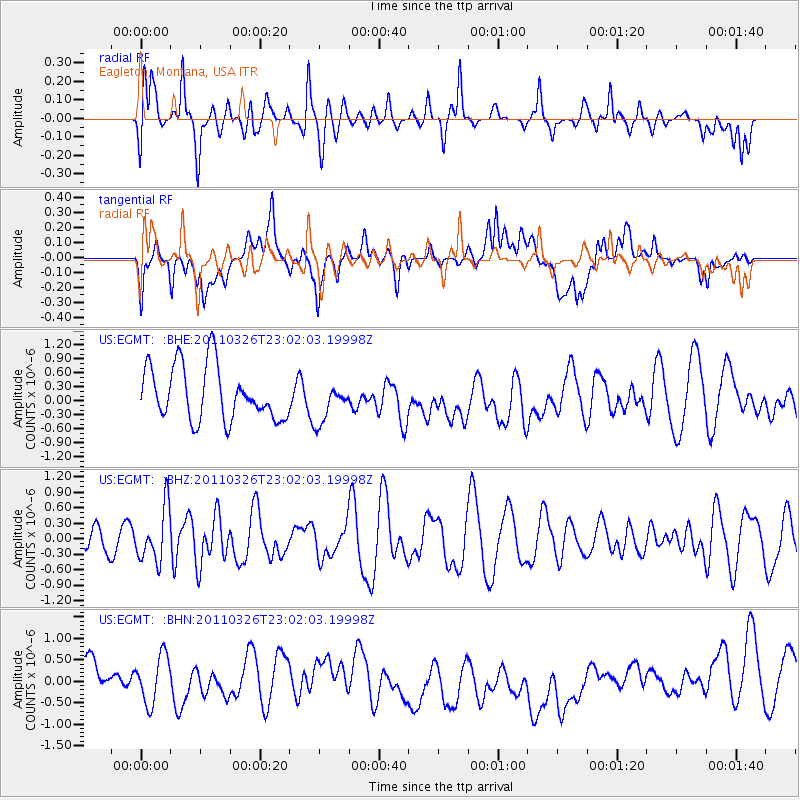
EGMT Eagleton, Montana, USA - Earthquake Result Viewer
*The percent match for this event was below the threshold and hence no stack was calculated.
| Earthquake location: |
Fiji Islands Region |
| Earthquake latitude/longitude: |
-15.9/-179.4 |
| Earthquake time(UTC): |
2011/03/26 (085) 22:49:41 GMT |
| Earthquake Depth: |
10 km |
| Earthquake Magnitude: |
5.7 MB, 5.9 MS, 6.1 MW, 6.0 MW |
| Earthquake Catalog/Contributor: |
WHDF/NEIC |
|
| Network: |
US United States National Seismic Network |
| Station: |
EGMT Eagleton, Montana, USA |
| Lat/Lon: |
48.02 N/109.75 W |
| Elevation: |
1055 m |
|
| Distance: |
88.7 deg |
| Az: |
39.019 deg |
| Baz: |
244.507 deg |
| Ray Param: |
$rayparam |
*The percent match for this event was below the threshold and hence was not used in the summary stack. |
|
| Radial Match: |
66.462265 % |
| Radial Bump: |
400 |
| Transverse Match: |
46.531567 % |
| Transverse Bump: |
400 |
| SOD ConfigId: |
356183 |
| Insert Time: |
2011-08-21 05:58:31.437 +0000 |
| GWidth: |
2.5 |
| Max Bumps: |
400 |
| Tol: |
0.001 |
|
Signal To Noise
| Channel | StoN | STA | LTA |
| US:EGMT: :BHZ:20110326T23:02:03.19998Z | 1.2031134 | 5.158755E-7 | 4.2878372E-7 |
| US:EGMT: :BHN:20110326T23:02:03.19998Z | 0.9946686 | 5.897901E-7 | 5.929513E-7 |
| US:EGMT: :BHE:20110326T23:02:03.19998Z | 0.7394942 | 4.2484913E-7 | 5.7451314E-7 |
| Arrivals |
| Ps | |
| PpPs | |
| PsPs/PpSs | |


