You are here: Home > Network List > TA - USArray Transportable Network (new EarthScope stations) Stations List
> Station O03D Paynes Creek, CA, USA > Earthquake Result Viewer
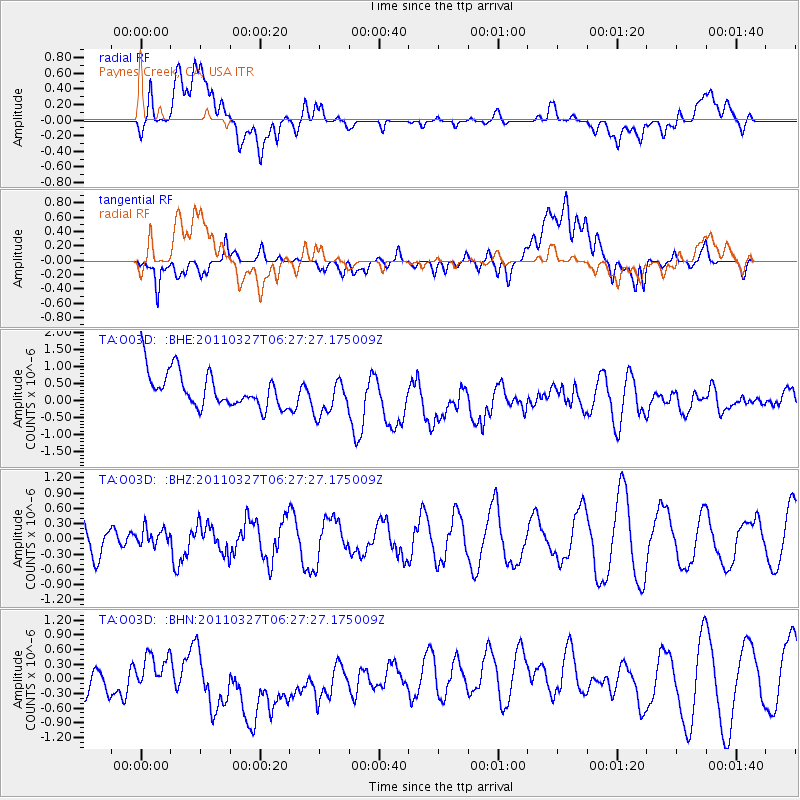
O03D Paynes Creek, CA, USA - Earthquake Result Viewer
*The percent match for this event was below the threshold and hence no stack was calculated.
| Earthquake location: |
Near Coast Of Chiapas, Mexico |
| Earthquake latitude/longitude: |
14.4/-92.3 |
| Earthquake time(UTC): |
2011/03/27 (086) 06:20:56 GMT |
| Earthquake Depth: |
35 km |
| Earthquake Magnitude: |
5.7 MW, 5.3 MS, 5.3 MB, 5.7 MW |
| Earthquake Catalog/Contributor: |
WHDF/NEIC |
|
| Network: |
TA USArray Transportable Network (new EarthScope stations) |
| Station: |
O03D Paynes Creek, CA, USA |
| Lat/Lon: |
40.29 N/121.80 W |
| Elevation: |
968 m |
|
| Distance: |
36.5 deg |
| Az: |
320.728 deg |
| Baz: |
126.677 deg |
| Ray Param: |
$rayparam |
*The percent match for this event was below the threshold and hence was not used in the summary stack. |
|
| Radial Match: |
42.51916 % |
| Radial Bump: |
400 |
| Transverse Match: |
36.071148 % |
| Transverse Bump: |
400 |
| SOD ConfigId: |
356183 |
| Insert Time: |
2011-08-21 06:38:38.150 +0000 |
| GWidth: |
2.5 |
| Max Bumps: |
400 |
| Tol: |
0.001 |
|
Signal To Noise
| Channel | StoN | STA | LTA |
| TA:O03D: :BHZ:20110327T06:27:27.175009Z | 0.31442428 | 1.7439461E-7 | 5.5464744E-7 |
| TA:O03D: :BHN:20110327T06:27:27.175009Z | 0.4876738 | 4.994344E-7 | 1.0241157E-6 |
| TA:O03D: :BHE:20110327T06:27:27.175009Z | 1.0594255 | 5.4529505E-7 | 5.147083E-7 |
| Arrivals |
| Ps | |
| PpPs | |
| PsPs/PpSs | |


