You are here: Home > Network List > TA - USArray Transportable Network (new EarthScope stations) Stations List
> Station D48A Paudash Township, ON, CAN > Earthquake Result Viewer
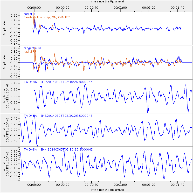
D48A Paudash Township, ON, CAN - Earthquake Result Viewer
*The percent match for this event was below the threshold and hence no stack was calculated.
| Earthquake location: |
Off W. Coast Of Baja California |
| Earthquake latitude/longitude: |
31.3/-119.5 |
| Earthquake time(UTC): |
2014/03/05 (064) 02:24:23 GMT |
| Earthquake Depth: |
9.0 km |
| Earthquake Magnitude: |
4.9 MW |
| Earthquake Catalog/Contributor: |
ISC/ISC |
|
| Network: |
TA USArray Transportable Network (new EarthScope stations) |
| Station: |
D48A Paudash Township, ON, CAN |
| Lat/Lon: |
47.17 N/81.81 W |
| Elevation: |
434 m |
|
| Distance: |
32.9 deg |
| Az: |
50.199 deg |
| Baz: |
254.678 deg |
| Ray Param: |
$rayparam |
*The percent match for this event was below the threshold and hence was not used in the summary stack. |
|
| Radial Match: |
74.31518 % |
| Radial Bump: |
400 |
| Transverse Match: |
49.808804 % |
| Transverse Bump: |
386 |
| SOD ConfigId: |
3390531 |
| Insert Time: |
2019-04-10 12:37:17.858 +0000 |
| GWidth: |
2.5 |
| Max Bumps: |
400 |
| Tol: |
0.001 |
|
Signal To Noise
| Channel | StoN | STA | LTA |
| TA:D48A: :BHZ:20140305T02:30:26.800004Z | 1.8332788 | 3.780401E-7 | 2.0620983E-7 |
| TA:D48A: :BHN:20140305T02:30:26.800004Z | 0.54233575 | 7.3272695E-8 | 1.3510578E-7 |
| TA:D48A: :BHE:20140305T02:30:26.800004Z | 1.2188591 | 2.0380949E-7 | 1.6721333E-7 |
| Arrivals |
| Ps | |
| PpPs | |
| PsPs/PpSs | |


