You are here: Home > Network List > TA - USArray Transportable Network (new EarthScope stations) Stations List
> Station G59A Clarenceville, QC, USA > Earthquake Result Viewer
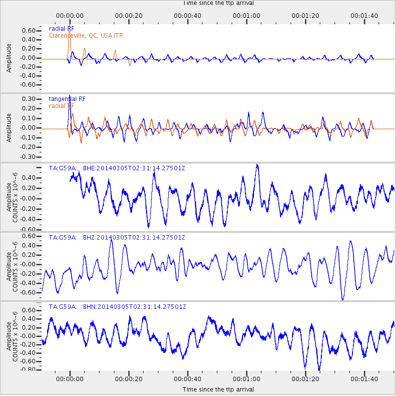
G59A Clarenceville, QC, USA - Earthquake Result Viewer
*The percent match for this event was below the threshold and hence no stack was calculated.
| Earthquake location: |
Off W. Coast Of Baja California |
| Earthquake latitude/longitude: |
31.3/-119.5 |
| Earthquake time(UTC): |
2014/03/05 (064) 02:24:23 GMT |
| Earthquake Depth: |
9.0 km |
| Earthquake Magnitude: |
4.9 MW |
| Earthquake Catalog/Contributor: |
ISC/ISC |
|
| Network: |
TA USArray Transportable Network (new EarthScope stations) |
| Station: |
G59A Clarenceville, QC, USA |
| Lat/Lon: |
45.08 N/73.18 W |
| Elevation: |
36 m |
|
| Distance: |
38.4 deg |
| Az: |
55.525 deg |
| Baz: |
265.218 deg |
| Ray Param: |
$rayparam |
*The percent match for this event was below the threshold and hence was not used in the summary stack. |
|
| Radial Match: |
64.65098 % |
| Radial Bump: |
400 |
| Transverse Match: |
39.41994 % |
| Transverse Bump: |
364 |
| SOD ConfigId: |
3390531 |
| Insert Time: |
2019-04-10 12:37:30.356 +0000 |
| GWidth: |
2.5 |
| Max Bumps: |
400 |
| Tol: |
0.001 |
|
Signal To Noise
| Channel | StoN | STA | LTA |
| TA:G59A: :BHZ:20140305T02:31:14.27501Z | 0.84092236 | 9.39034E-7 | 1.1166716E-6 |
| TA:G59A: :BHN:20140305T02:31:14.27501Z | 0.9602783 | 5.955877E-7 | 6.2022406E-7 |
| TA:G59A: :BHE:20140305T02:31:14.27501Z | 1.3575771 | 2.8434198E-7 | 2.0944812E-7 |
| Arrivals |
| Ps | |
| PpPs | |
| PsPs/PpSs | |


