You are here: Home > Network List > AZ - ANZA Regional Network Stations List
> Station RDM AZ.RDM > Earthquake Result Viewer
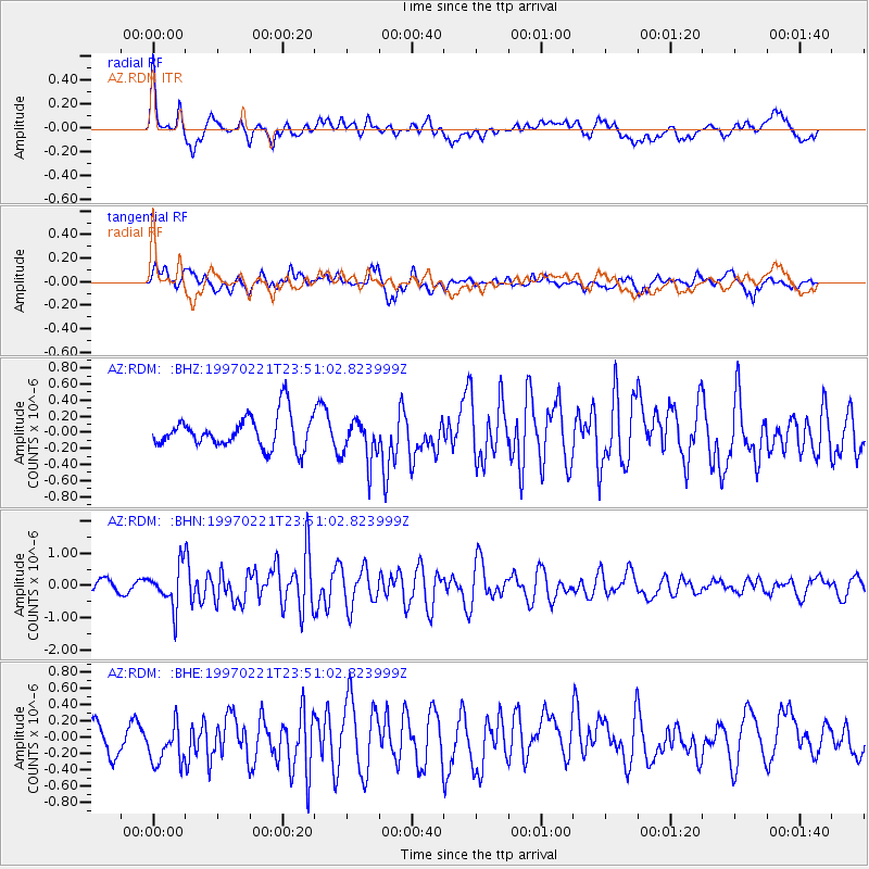
RDM AZ.RDM - Earthquake Result Viewer
*The percent match for this event was below the threshold and hence no stack was calculated.
| Earthquake location: |
East Of Kuril Islands |
| Earthquake latitude/longitude: |
43.8/149.2 |
| Earthquake time(UTC): |
1997/02/21 (052) 23:40:24 GMT |
| Earthquake Depth: |
33 km |
| Earthquake Magnitude: |
6.1 MB, 5.6 MS, 6.1 UNKNOWN, 6.1 MW |
| Earthquake Catalog/Contributor: |
WHDF/NEIC |
|
| Network: |
AZ ANZA Regional Network |
| Station: |
RDM AZ.RDM |
| Lat/Lon: |
33.63 N/116.85 W |
| Elevation: |
1365 m |
|
| Distance: |
70.2 deg |
| Az: |
62.193 deg |
| Baz: |
309.892 deg |
| Ray Param: |
$rayparam |
*The percent match for this event was below the threshold and hence was not used in the summary stack. |
|
| Radial Match: |
79.13983 % |
| Radial Bump: |
400 |
| Transverse Match: |
62.975502 % |
| Transverse Bump: |
400 |
| SOD ConfigId: |
4480 |
| Insert Time: |
2010-02-26 20:40:01.664 +0000 |
| GWidth: |
2.5 |
| Max Bumps: |
400 |
| Tol: |
0.001 |
|
Signal To Noise
| Channel | StoN | STA | LTA |
| AZ:RDM: :BHN:19970221T23:51:02.823999Z | 4.1368775 | 6.318169E-7 | 1.5272796E-7 |
| AZ:RDM: :BHE:19970221T23:51:02.823999Z | 1.7769319 | 2.8397392E-7 | 1.5981136E-7 |
| AZ:RDM: :BHZ:19970221T23:51:02.823999Z | 1.3461777 | 2.7059693E-7 | 2.010113E-7 |
| Arrivals |
| Ps | |
| PpPs | |
| PsPs/PpSs | |


