You are here: Home > Network List > TA - USArray Transportable Network (new EarthScope stations) Stations List
> Station 435B Jarrell, TX, USA > Earthquake Result Viewer
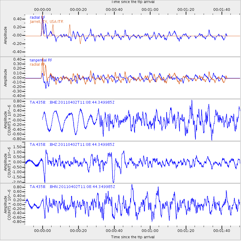
435B Jarrell, TX, USA - Earthquake Result Viewer
*The percent match for this event was below the threshold and hence no stack was calculated.
| Earthquake location: |
Northern Chile |
| Earthquake latitude/longitude: |
-19.6/-69.1 |
| Earthquake time(UTC): |
2011/04/02 (092) 10:59:37 GMT |
| Earthquake Depth: |
84 km |
| Earthquake Magnitude: |
6.0 MB, 5.9 MW, 5.9 MW |
| Earthquake Catalog/Contributor: |
WHDF/NEIC |
|
| Network: |
TA USArray Transportable Network (new EarthScope stations) |
| Station: |
435B Jarrell, TX, USA |
| Lat/Lon: |
30.78 N/97.58 W |
| Elevation: |
248 m |
|
| Distance: |
57.1 deg |
| Az: |
330.693 deg |
| Baz: |
147.568 deg |
| Ray Param: |
$rayparam |
*The percent match for this event was below the threshold and hence was not used in the summary stack. |
|
| Radial Match: |
68.59826 % |
| Radial Bump: |
398 |
| Transverse Match: |
56.02178 % |
| Transverse Bump: |
400 |
| SOD ConfigId: |
356183 |
| Insert Time: |
2011-09-23 09:32:48.170 +0000 |
| GWidth: |
2.5 |
| Max Bumps: |
400 |
| Tol: |
0.001 |
|
Signal To Noise
| Channel | StoN | STA | LTA |
| TA:435B: :BHZ:20110402T11:08:44.349985Z | 2.5857093 | 7.3340465E-7 | 2.836377E-7 |
| TA:435B: :BHN:20110402T11:08:44.349985Z | 1.6935443 | 2.4467994E-7 | 1.4447802E-7 |
| TA:435B: :BHE:20110402T11:08:44.349985Z | 0.84212726 | 2.5445866E-7 | 3.0216177E-7 |
| Arrivals |
| Ps | |
| PpPs | |
| PsPs/PpSs | |


