You are here: Home > Network List > TA - USArray Transportable Network (new EarthScope stations) Stations List
> Station 339A Huntington, TX, USA > Earthquake Result Viewer
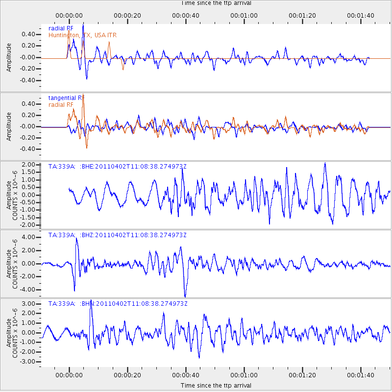
339A Huntington, TX, USA - Earthquake Result Viewer
*The percent match for this event was below the threshold and hence no stack was calculated.
| Earthquake location: |
Northern Chile |
| Earthquake latitude/longitude: |
-19.6/-69.1 |
| Earthquake time(UTC): |
2011/04/02 (092) 10:59:37 GMT |
| Earthquake Depth: |
84 km |
| Earthquake Magnitude: |
6.0 MB, 5.9 MW, 5.9 MW |
| Earthquake Catalog/Contributor: |
WHDF/NEIC |
|
| Network: |
TA USArray Transportable Network (new EarthScope stations) |
| Station: |
339A Huntington, TX, USA |
| Lat/Lon: |
31.33 N/94.56 W |
| Elevation: |
82 m |
|
| Distance: |
56.2 deg |
| Az: |
333.701 deg |
| Baz: |
150.778 deg |
| Ray Param: |
$rayparam |
*The percent match for this event was below the threshold and hence was not used in the summary stack. |
|
| Radial Match: |
72.15871 % |
| Radial Bump: |
400 |
| Transverse Match: |
56.036068 % |
| Transverse Bump: |
400 |
| SOD ConfigId: |
356183 |
| Insert Time: |
2011-09-23 09:34:57.809 +0000 |
| GWidth: |
2.5 |
| Max Bumps: |
400 |
| Tol: |
0.001 |
|
Signal To Noise
| Channel | StoN | STA | LTA |
| TA:339A: :BHZ:20110402T11:08:38.274973Z | 7.998893 | 1.7875616E-6 | 2.2347612E-7 |
| TA:339A: :BHN:20110402T11:08:38.274973Z | 0.7190026 | 2.84605E-7 | 3.95833E-7 |
| TA:339A: :BHE:20110402T11:08:38.274973Z | 1.1945318 | 5.618103E-7 | 4.7031835E-7 |
| Arrivals |
| Ps | |
| PpPs | |
| PsPs/PpSs | |


