You are here: Home > Network List > TA - USArray Transportable Network (new EarthScope stations) Stations List
> Station N34A Lincoln, NE, USA > Earthquake Result Viewer
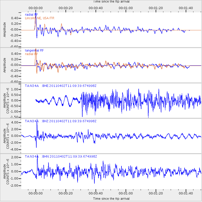
N34A Lincoln, NE, USA - Earthquake Result Viewer
*The percent match for this event was below the threshold and hence no stack was calculated.
| Earthquake location: |
Northern Chile |
| Earthquake latitude/longitude: |
-19.6/-69.1 |
| Earthquake time(UTC): |
2011/04/02 (092) 10:59:37 GMT |
| Earthquake Depth: |
84 km |
| Earthquake Magnitude: |
6.0 MB, 5.9 MW, 5.9 MW |
| Earthquake Catalog/Contributor: |
WHDF/NEIC |
|
| Network: |
TA USArray Transportable Network (new EarthScope stations) |
| Station: |
N34A Lincoln, NE, USA |
| Lat/Lon: |
40.84 N/96.50 W |
| Elevation: |
401 m |
|
| Distance: |
65.3 deg |
| Az: |
337.368 deg |
| Baz: |
151.431 deg |
| Ray Param: |
$rayparam |
*The percent match for this event was below the threshold and hence was not used in the summary stack. |
|
| Radial Match: |
64.13813 % |
| Radial Bump: |
400 |
| Transverse Match: |
59.358677 % |
| Transverse Bump: |
400 |
| SOD ConfigId: |
356183 |
| Insert Time: |
2011-09-23 09:45:10.643 +0000 |
| GWidth: |
2.5 |
| Max Bumps: |
400 |
| Tol: |
0.001 |
|
Signal To Noise
| Channel | StoN | STA | LTA |
| TA:N34A: :BHZ:20110402T11:09:39.674998Z | 7.3100977 | 1.2878065E-6 | 1.7616816E-7 |
| TA:N34A: :BHN:20110402T11:09:39.674998Z | 4.2355094 | 6.738456E-7 | 1.5909436E-7 |
| TA:N34A: :BHE:20110402T11:09:39.674998Z | 2.4053016 | 5.4372777E-7 | 2.2605388E-7 |
| Arrivals |
| Ps | |
| PpPs | |
| PsPs/PpSs | |


