You are here: Home > Network List > TA - USArray Transportable Network (new EarthScope stations) Stations List
> Station G36A St. Michael, MN, USA > Earthquake Result Viewer
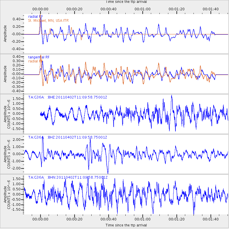
G36A St. Michael, MN, USA - Earthquake Result Viewer
*The percent match for this event was below the threshold and hence no stack was calculated.
| Earthquake location: |
Northern Chile |
| Earthquake latitude/longitude: |
-19.6/-69.1 |
| Earthquake time(UTC): |
2011/04/02 (092) 10:59:37 GMT |
| Earthquake Depth: |
84 km |
| Earthquake Magnitude: |
6.0 MB, 5.9 MW, 5.9 MW |
| Earthquake Catalog/Contributor: |
WHDF/NEIC |
|
| Network: |
TA USArray Transportable Network (new EarthScope stations) |
| Station: |
G36A St. Michael, MN, USA |
| Lat/Lon: |
45.23 N/93.75 W |
| Elevation: |
293 m |
|
| Distance: |
68.3 deg |
| Az: |
341.482 deg |
| Baz: |
154.924 deg |
| Ray Param: |
$rayparam |
*The percent match for this event was below the threshold and hence was not used in the summary stack. |
|
| Radial Match: |
54.34625 % |
| Radial Bump: |
400 |
| Transverse Match: |
72.556046 % |
| Transverse Bump: |
400 |
| SOD ConfigId: |
356183 |
| Insert Time: |
2011-09-23 10:10:32.789 +0000 |
| GWidth: |
2.5 |
| Max Bumps: |
400 |
| Tol: |
0.001 |
|
Signal To Noise
| Channel | StoN | STA | LTA |
| TA:G36A: :BHZ:20110402T11:09:58.75001Z | 3.5286212 | 9.519635E-7 | 2.697834E-7 |
| TA:G36A: :BHN:20110402T11:09:58.75001Z | 1.5391629 | 5.906507E-7 | 3.8374802E-7 |
| TA:G36A: :BHE:20110402T11:09:58.75001Z | 0.7107649 | 2.9659458E-7 | 4.1728927E-7 |
| Arrivals |
| Ps | |
| PpPs | |
| PsPs/PpSs | |


