You are here: Home > Network List > AZ - ANZA Regional Network Stations List
> Station SHUM AZ.SHUM > Earthquake Result Viewer
SHUM AZ.SHUM - Earthquake Result Viewer
| Earthquake location: |
Kermadec Islands Region |
| Earthquake latitude/longitude: |
-31.2/180.0 |
| Earthquake time(UTC): |
1996/11/05 (310) 09:41:34 GMT |
| Earthquake Depth: |
369 km |
| Earthquake Magnitude: |
5.9 MB, 6.8 UNKNOWN, 6.7 MW |
| Earthquake Catalog/Contributor: |
WHDF/NEIC |
|
| Network: |
AZ ANZA Regional Network |
| Station: |
SHUM AZ.SHUM |
| Lat/Lon: |
33.63 N/116.44 W |
| Elevation: |
1195 m |
|
| Distance: |
88.0 deg |
| Az: |
48.372 deg |
| Baz: |
230.178 deg |
| Ray Param: |
0.04196394 |
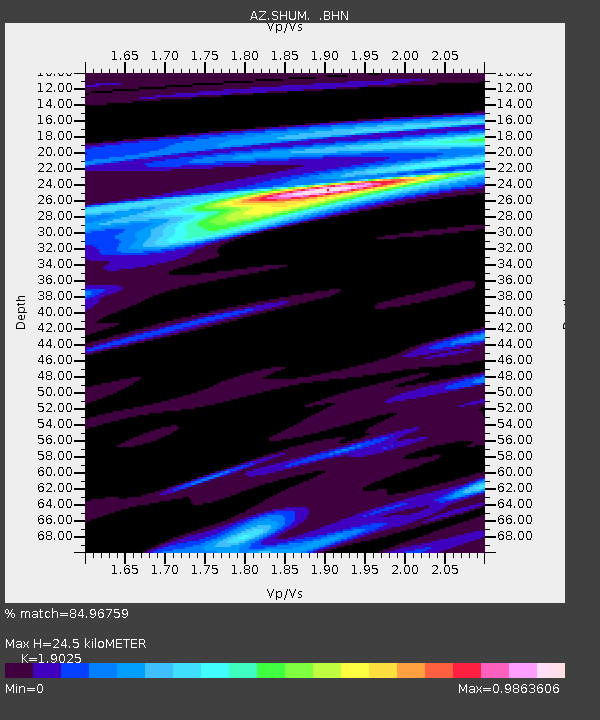
| Estimated Moho Depth: |
24.5 km |
| Estimated Crust Vp/Vs: |
1.90 |
| Assumed Crust Vp: |
6.264 km/s |
| Estimated Crust Vs: |
3.292 km/s |
| Estimated Crust Poisson's Ratio: |
0.31 |
|
| Radial Match: |
84.96759 % |
| Radial Bump: |
400 |
| Transverse Match: |
60.145466 % |
| Transverse Bump: |
400 |
| SOD ConfigId: |
6273 |
| Insert Time: |
2010-02-26 20:40:31.131 +0000 |
| GWidth: |
2.5 |
| Max Bumps: |
400 |
| Tol: |
0.001 |
|

Signal To Noise
| Channel | StoN | STA | LTA |
| AZ:SHUM: :BHN:19961105T09:53:12.700Z | 1.5809071 | 7.0945515E-7 | 4.4876458E-7 |
| AZ:SHUM: :BHE:19961105T09:53:12.700Z | 1.3067974 | 2.6509483E-7 | 2.028584E-7 |
| AZ:SHUM: :BHZ:19961105T09:53:12.700Z | 5.33162 | 1.691484E-6 | 3.1725517E-7 |
| Arrivals |
| Ps | 3.6 SECOND |
| PpPs | 11 SECOND |
| PsPs/PpSs | 15 SECOND |


