You are here: Home > Network List > TA - USArray Transportable Network (new EarthScope stations) Stations List
> Station Z41A Richland Creek Farm, El Dorado, AR, USA > Earthquake Result Viewer
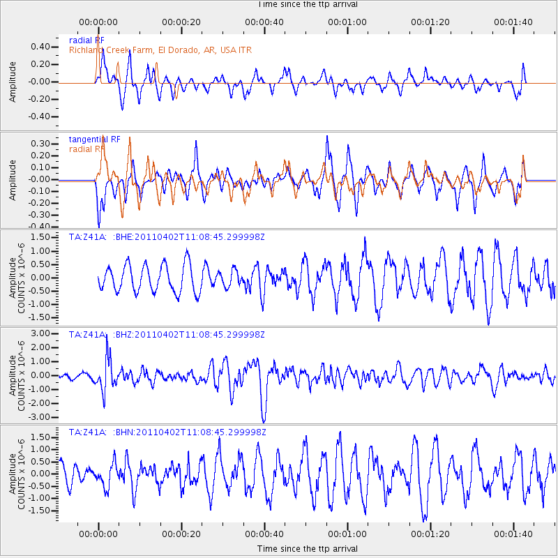
Z41A Richland Creek Farm, El Dorado, AR, USA - Earthquake Result Viewer
*The percent match for this event was below the threshold and hence no stack was calculated.
| Earthquake location: |
Northern Chile |
| Earthquake latitude/longitude: |
-19.6/-69.1 |
| Earthquake time(UTC): |
2011/04/02 (092) 10:59:37 GMT |
| Earthquake Depth: |
84 km |
| Earthquake Magnitude: |
6.0 MB, 5.9 MW, 5.9 MW |
| Earthquake Catalog/Contributor: |
WHDF/NEIC |
|
| Network: |
TA USArray Transportable Network (new EarthScope stations) |
| Station: |
Z41A Richland Creek Farm, El Dorado, AR, USA |
| Lat/Lon: |
33.26 N/92.80 W |
| Elevation: |
62 m |
|
| Distance: |
57.2 deg |
| Az: |
336.348 deg |
| Baz: |
153.162 deg |
| Ray Param: |
$rayparam |
*The percent match for this event was below the threshold and hence was not used in the summary stack. |
|
| Radial Match: |
57.721645 % |
| Radial Bump: |
385 |
| Transverse Match: |
54.369778 % |
| Transverse Bump: |
393 |
| SOD ConfigId: |
356183 |
| Insert Time: |
2011-09-23 10:43:26.771 +0000 |
| GWidth: |
2.5 |
| Max Bumps: |
400 |
| Tol: |
0.001 |
|
Signal To Noise
| Channel | StoN | STA | LTA |
| TA:Z41A: :BHZ:20110402T11:08:45.299998Z | 5.4641376 | 1.136343E-6 | 2.0796384E-7 |
| TA:Z41A: :BHN:20110402T11:08:45.299998Z | 0.7144291 | 4.7542514E-7 | 6.6546164E-7 |
| TA:Z41A: :BHE:20110402T11:08:45.299998Z | 0.5986149 | 2.9912079E-7 | 4.996882E-7 |
| Arrivals |
| Ps | |
| PpPs | |
| PsPs/PpSs | |


