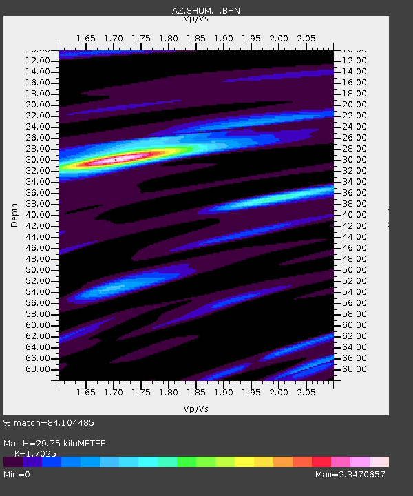
SHUM AZ.SHUM - Earthquake Result Viewer
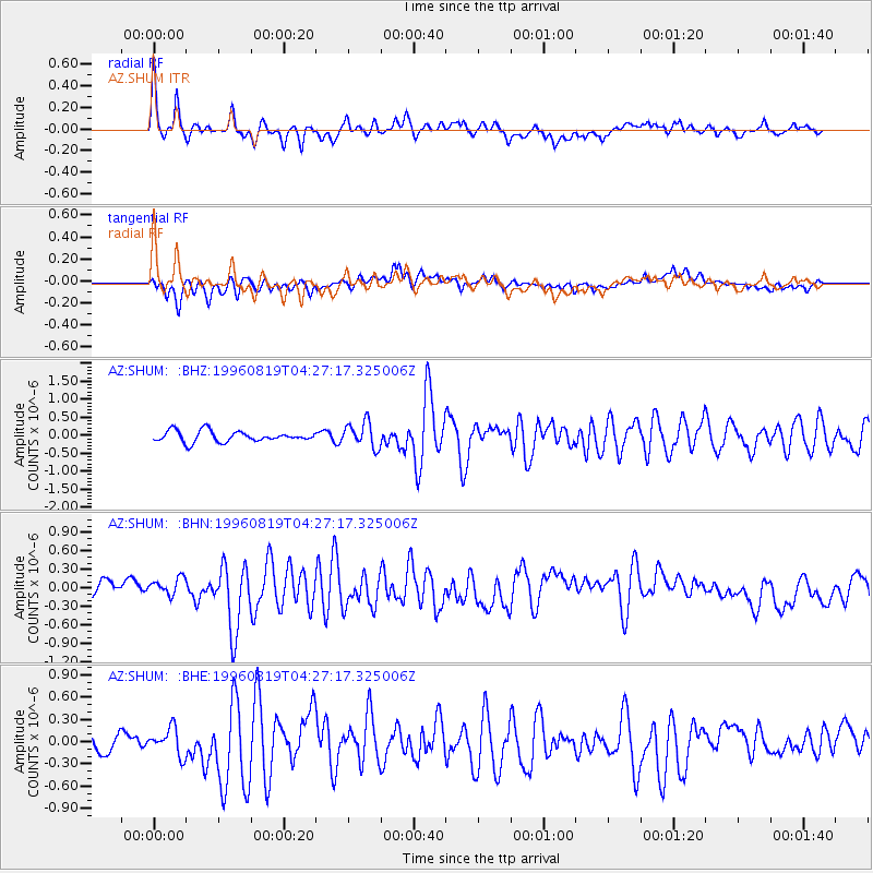
Earthquake location: Andreanof Islands, Aleutian Is.
Earthquake latitude/longitude: 51.5/-178.4
Earthquake time(UTC): 1996/08/19 (232) 04:19:16 GMT
Earthquake Depth: 33 km
Earthquake Magnitude: 5.7 MB, 5.6 MS, 6.0 UNKNOWN, 5.7 ML
Earthquake Catalog/Contributor: WHDF/NEIC
Network: AZ ANZA Regional Network
Station: SHUM AZ.SHUM
Lat/Lon: 33.63 N/116.44 W
Elevation: 1195 m
Distance: 47.5 deg
Az: 86.994 deg
Baz: 311.498 deg
Ray Param: 0.06989201
Estimated Moho Depth: 29.75 km
Estimated Crust Vp/Vs: 1.70
Assumed Crust Vp: 6.264 km/s
Estimated Crust Vs: 3.679 km/s
Estimated Crust Poisson's Ratio: 0.24
Radial Match: 84.104485 %
Radial Bump: 398
Transverse Match: 66.05717 %
Transverse Bump: 400
SOD ConfigId: 6273
Insert Time: 2010-02-26 20:40:37.442 +0000
GWidth: 2.5
Max Bumps: 400
Tol: 0.001

Signal To Noise

ChannelStoNSTALTA
AZ:SHUM: :BHN:19960819T04:27:17.325006Z1.37717961.3258652E-79.627396E-8
AZ:SHUM: :BHE:19960819T04:27:17.325006Z1.20489371.791841E-71.4871361E-7
AZ:SHUM: :BHZ:19960819T04:27:17.325006Z2.34669113.5197195E-71.4998648E-7
Arrivals
Ps3.5 SECOND
PpPs12 SECOND
PsPs/PpSs16 SECOND