You are here: Home > Network List > AZ - ANZA Regional Network Stations List
> Station SHUM AZ.SHUM > Earthquake Result Viewer
SHUM AZ.SHUM - Earthquake Result Viewer
| Earthquake location: |
Mariana Islands |
| Earthquake latitude/longitude: |
17.4/145.5 |
| Earthquake time(UTC): |
1996/06/09 (161) 01:12:16 GMT |
| Earthquake Depth: |
149 km |
| Earthquake Magnitude: |
6.0 MB, 5.9 MS, 6.5 UNKNOWN, 6.5 MW |
| Earthquake Catalog/Contributor: |
WHDF/NEIC |
|
| Network: |
AZ ANZA Regional Network |
| Station: |
SHUM AZ.SHUM |
| Lat/Lon: |
33.63 N/116.44 W |
| Elevation: |
1195 m |
|
| Distance: |
87.0 deg |
| Az: |
55.804 deg |
| Baz: |
288.853 deg |
| Ray Param: |
0.043301415 |
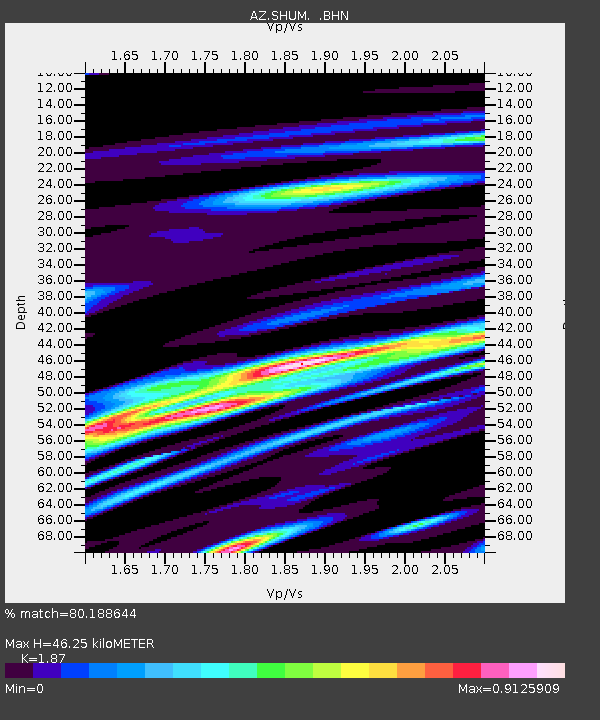
| Estimated Moho Depth: |
46.25 km |
| Estimated Crust Vp/Vs: |
1.87 |
| Assumed Crust Vp: |
6.264 km/s |
| Estimated Crust Vs: |
3.35 km/s |
| Estimated Crust Poisson's Ratio: |
0.30 |
|
| Radial Match: |
80.188644 % |
| Radial Bump: |
400 |
| Transverse Match: |
38.79246 % |
| Transverse Bump: |
344 |
| SOD ConfigId: |
6273 |
| Insert Time: |
2010-02-26 20:40:45.691 +0000 |
| GWidth: |
2.5 |
| Max Bumps: |
400 |
| Tol: |
0.001 |
|
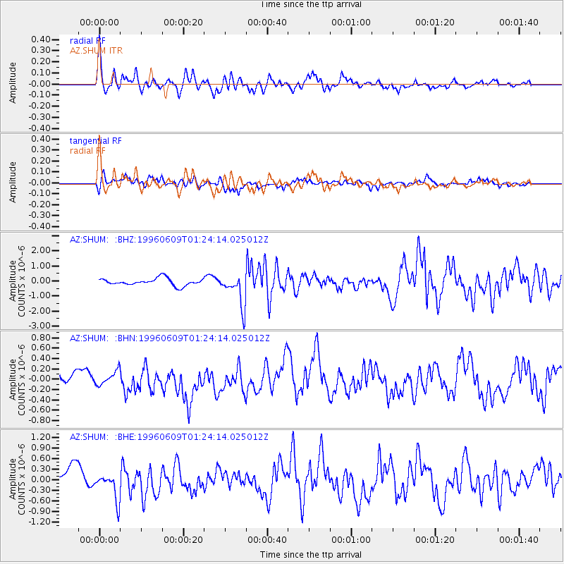
Signal To Noise
| Channel | StoN | STA | LTA |
| AZ:SHUM: :BHN:19960609T01:24:14.025012Z | 0.4521908 | 1.3385524E-7 | 2.9601495E-7 |
| AZ:SHUM: :BHE:19960609T01:24:14.025012Z | 1.4031363 | 4.029144E-7 | 2.8715274E-7 |
| AZ:SHUM: :BHZ:19960609T01:24:14.025012Z | 4.7116895 | 1.109961E-6 | 2.35576E-7 |
| Arrivals |
| Ps | 6.6 SECOND |
| PpPs | 21 SECOND |
| PsPs/PpSs | 27 SECOND |


