You are here: Home > Network List > US - United States National Seismic Network Stations List
> Station AMTX Amarillo, Texas, USA > Earthquake Result Viewer
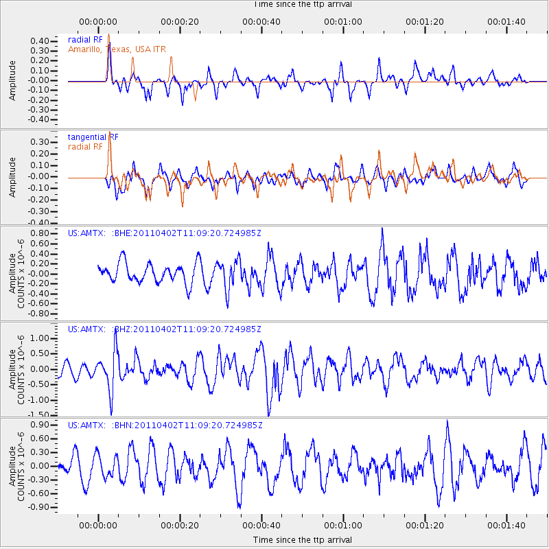
AMTX Amarillo, Texas, USA - Earthquake Result Viewer
*The percent match for this event was below the threshold and hence no stack was calculated.
| Earthquake location: |
Northern Chile |
| Earthquake latitude/longitude: |
-19.6/-69.1 |
| Earthquake time(UTC): |
2011/04/02 (092) 10:59:37 GMT |
| Earthquake Depth: |
84 km |
| Earthquake Magnitude: |
6.0 MB, 5.9 MW, 5.9 MW |
| Earthquake Catalog/Contributor: |
WHDF/NEIC |
|
| Network: |
US United States National Seismic Network |
| Station: |
AMTX Amarillo, Texas, USA |
| Lat/Lon: |
34.53 N/101.41 W |
| Elevation: |
1010 m |
|
| Distance: |
62.0 deg |
| Az: |
329.978 deg |
| Baz: |
145.151 deg |
| Ray Param: |
$rayparam |
*The percent match for this event was below the threshold and hence was not used in the summary stack. |
|
| Radial Match: |
53.277843 % |
| Radial Bump: |
338 |
| Transverse Match: |
68.85734 % |
| Transverse Bump: |
400 |
| SOD ConfigId: |
356183 |
| Insert Time: |
2011-09-23 11:00:30.377 +0000 |
| GWidth: |
2.5 |
| Max Bumps: |
400 |
| Tol: |
0.001 |
|
Signal To Noise
| Channel | StoN | STA | LTA |
| US:AMTX: :BHZ:20110402T11:09:20.724985Z | 3.8432653 | 6.444249E-7 | 1.676764E-7 |
| US:AMTX: :BHN:20110402T11:09:20.724985Z | 1.1696959 | 2.455613E-7 | 2.0993603E-7 |
| US:AMTX: :BHE:20110402T11:09:20.724985Z | 1.7523565 | 2.9716767E-7 | 1.6958174E-7 |
| Arrivals |
| Ps | |
| PpPs | |
| PsPs/PpSs | |


