You are here: Home > Network List > AZ - ANZA Regional Network Stations List
> Station SHUM AZ.SHUM > Earthquake Result Viewer
SHUM AZ.SHUM - Earthquake Result Viewer
| Earthquake location: |
South Of Panama |
| Earthquake latitude/longitude: |
2.4/-79.3 |
| Earthquake time(UTC): |
1996/04/27 (118) 08:40:41 GMT |
| Earthquake Depth: |
10 km |
| Earthquake Magnitude: |
4.8 MB, 5.9 MS, 6.2 UNKNOWN, 6.0 MW |
| Earthquake Catalog/Contributor: |
WHDF/NEIC |
|
| Network: |
AZ ANZA Regional Network |
| Station: |
SHUM AZ.SHUM |
| Lat/Lon: |
33.63 N/116.44 W |
| Elevation: |
1195 m |
|
| Distance: |
46.6 deg |
| Az: |
316.127 deg |
| Baz: |
123.902 deg |
| Ray Param: |
0.07056255 |
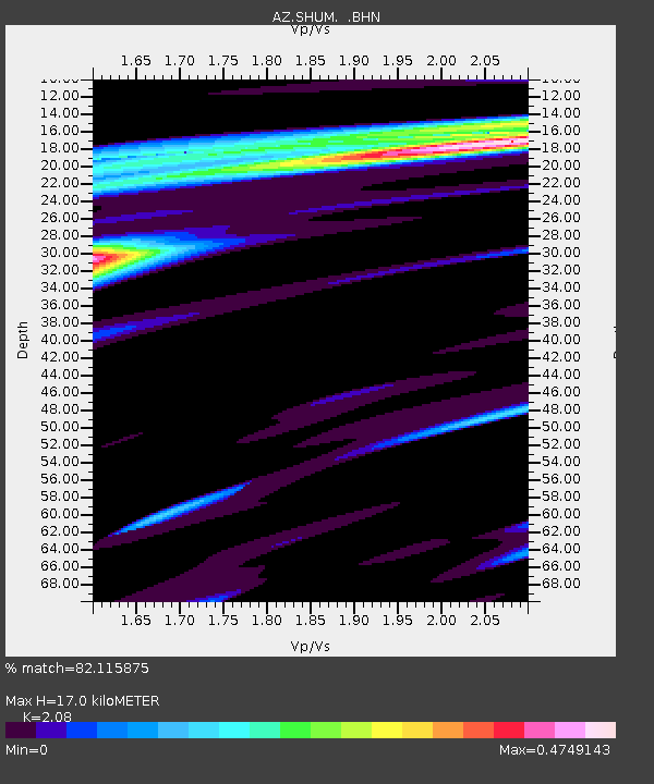
| Estimated Moho Depth: |
17.0 km |
| Estimated Crust Vp/Vs: |
2.08 |
| Assumed Crust Vp: |
6.264 km/s |
| Estimated Crust Vs: |
3.011 km/s |
| Estimated Crust Poisson's Ratio: |
0.35 |
|
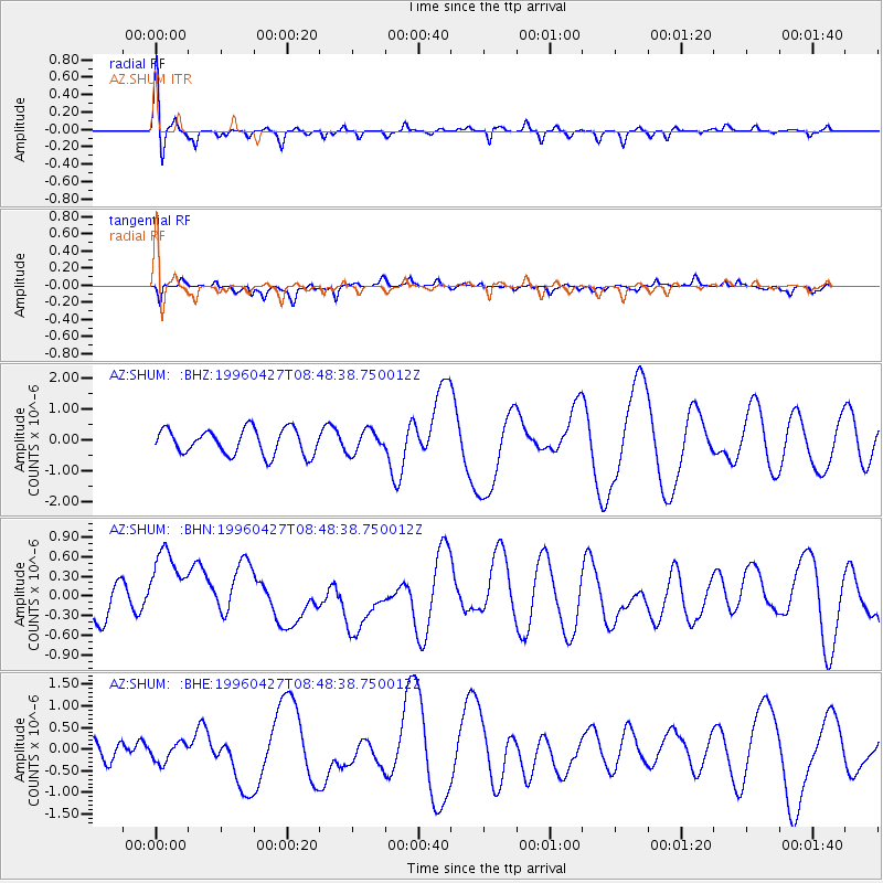
| Radial Match: |
82.115875 % |
| Radial Bump: |
400 |
| Transverse Match: |
60.96669 % |
| Transverse Bump: |
400 |
| SOD ConfigId: |
6273 |
| Insert Time: |
2010-02-26 20:40:49.109 +0000 |
| GWidth: |
2.5 |
| Max Bumps: |
400 |
| Tol: |
0.001 |
|
Signal To Noise
| Channel | StoN | STA | LTA |
| AZ:SHUM: :BHN:19960427T08:48:38.750012Z | 3.6170819 | 7.283318E-7 | 2.0135896E-7 |
| AZ:SHUM: :BHE:19960427T08:48:38.750012Z | 1.285181 | 2.3330475E-7 | 1.8153452E-7 |
| AZ:SHUM: :BHZ:19960427T08:48:38.750012Z | 0.8659564 | 3.5857707E-7 | 4.1408214E-7 |
| Arrivals |
| Ps | 3.1 SECOND |
| PpPs | 8.0 SECOND |
| PsPs/PpSs | 11 SECOND |


