You are here: Home > Network List > AZ - ANZA Regional Network Stations List
> Station SHUM AZ.SHUM > Earthquake Result Viewer
SHUM AZ.SHUM - Earthquake Result Viewer
| Earthquake location: |
Santa Cruz Islands |
| Earthquake latitude/longitude: |
-12.9/166.5 |
| Earthquake time(UTC): |
1997/04/21 (111) 12:06:34 GMT |
| Earthquake Depth: |
33 km |
| Earthquake Magnitude: |
6.1 MB |
| Earthquake Catalog/Contributor: |
WHDF/NEIC |
|
| Network: |
AZ ANZA Regional Network |
| Station: |
SHUM AZ.SHUM |
| Lat/Lon: |
33.63 N/116.44 W |
| Elevation: |
1195 m |
|
| Distance: |
86.6 deg |
| Az: |
54.556 deg |
| Baz: |
252.215 deg |
| Ray Param: |
0.043905184 |
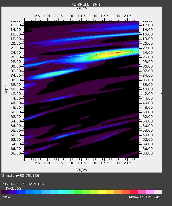
| Estimated Moho Depth: |
23.75 km |
| Estimated Crust Vp/Vs: |
2.01 |
| Assumed Crust Vp: |
6.264 km/s |
| Estimated Crust Vs: |
3.124 km/s |
| Estimated Crust Poisson's Ratio: |
0.33 |
|
| Radial Match: |
85.781136 % |
| Radial Bump: |
303 |
| Transverse Match: |
48.36528 % |
| Transverse Bump: |
390 |
| SOD ConfigId: |
9875 |
| Insert Time: |
2010-02-26 20:40:57.103 +0000 |
| GWidth: |
2.5 |
| Max Bumps: |
400 |
| Tol: |
0.001 |
|
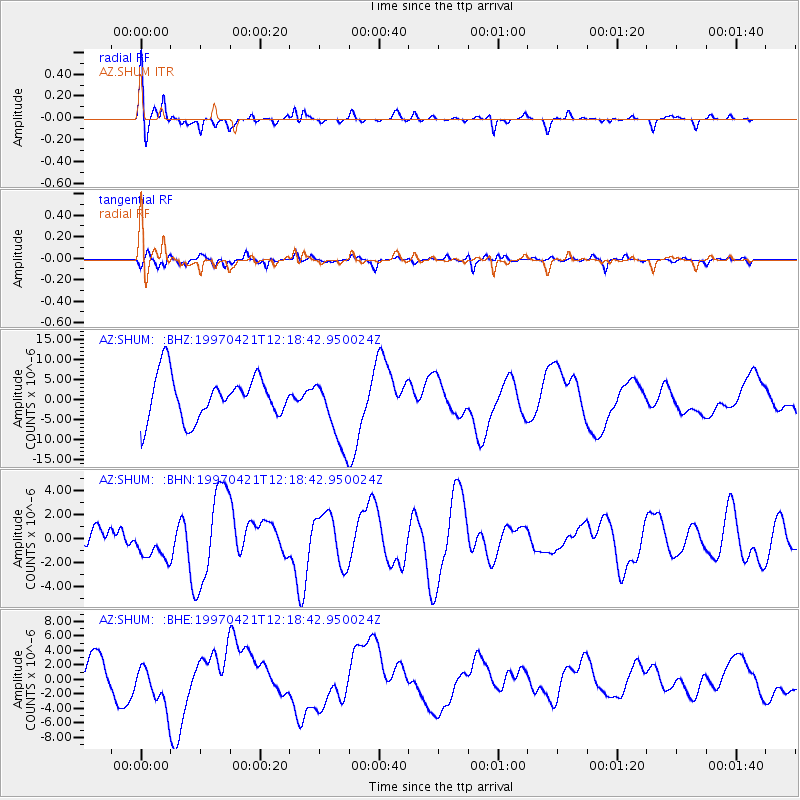
Signal To Noise
| Channel | StoN | STA | LTA |
| AZ:SHUM: :BHN:19970421T12:18:42.950024Z | 0.9216865 | 1.4578637E-6 | 1.581735E-6 |
| AZ:SHUM: :BHE:19970421T12:18:42.950024Z | 1.6108516 | 3.1006914E-6 | 1.924877E-6 |
| AZ:SHUM: :BHZ:19970421T12:18:42.950024Z | 1.637544 | 8.91998E-6 | 5.4471698E-6 |
| Arrivals |
| Ps | 3.9 SECOND |
| PpPs | 11 SECOND |
| PsPs/PpSs | 15 SECOND |


