You are here: Home > Network List > AZ - ANZA Regional Network Stations List
> Station SHUM AZ.SHUM > Earthquake Result Viewer
SHUM AZ.SHUM - Earthquake Result Viewer
| Earthquake location: |
Santa Cruz Islands |
| Earthquake latitude/longitude: |
-12.6/166.7 |
| Earthquake time(UTC): |
1997/04/21 (111) 12:02:26 GMT |
| Earthquake Depth: |
33 km |
| Earthquake Magnitude: |
6.4 MB, 7.9 MS, 7.9 UNKNOWN, 7.8 MW |
| Earthquake Catalog/Contributor: |
WHDF/NEIC |
|
| Network: |
AZ ANZA Regional Network |
| Station: |
SHUM AZ.SHUM |
| Lat/Lon: |
33.63 N/116.44 W |
| Elevation: |
1195 m |
|
| Distance: |
86.2 deg |
| Az: |
54.517 deg |
| Baz: |
252.336 deg |
| Ray Param: |
0.044149544 |
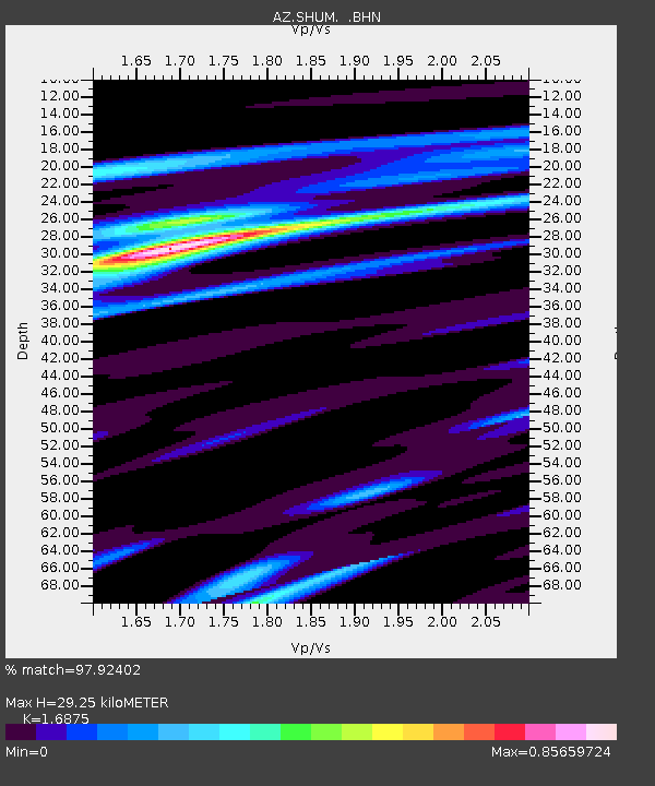
| Estimated Moho Depth: |
29.25 km |
| Estimated Crust Vp/Vs: |
1.69 |
| Assumed Crust Vp: |
6.264 km/s |
| Estimated Crust Vs: |
3.712 km/s |
| Estimated Crust Poisson's Ratio: |
0.23 |
|
| Radial Match: |
97.92402 % |
| Radial Bump: |
298 |
| Transverse Match: |
90.83325 % |
| Transverse Bump: |
400 |
| SOD ConfigId: |
9875 |
| Insert Time: |
2010-02-26 20:40:58.176 +0000 |
| GWidth: |
2.5 |
| Max Bumps: |
400 |
| Tol: |
0.001 |
|
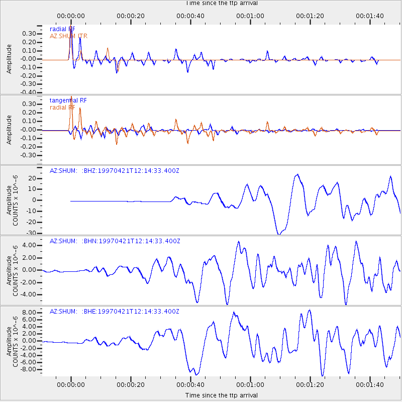
Signal To Noise
| Channel | StoN | STA | LTA |
| AZ:SHUM: :BHN:19970421T12:14:33.400Z | 0.6263708 | 8.8473904E-8 | 1.4124845E-7 |
| AZ:SHUM: :BHE:19970421T12:14:33.400Z | 2.3875744 | 4.1772287E-7 | 1.74957E-7 |
| AZ:SHUM: :BHZ:19970421T12:14:33.400Z | 6.807549 | 1.0982197E-6 | 1.6132381E-7 |
| Arrivals |
| Ps | 3.3 SECOND |
| PpPs | 12 SECOND |
| PsPs/PpSs | 16 SECOND |


