You are here: Home > Network List > CI - Caltech Regional Seismic Network Stations List
> Station SWS Sam W. Stewart, Westmorland, CA, USA > Earthquake Result Viewer
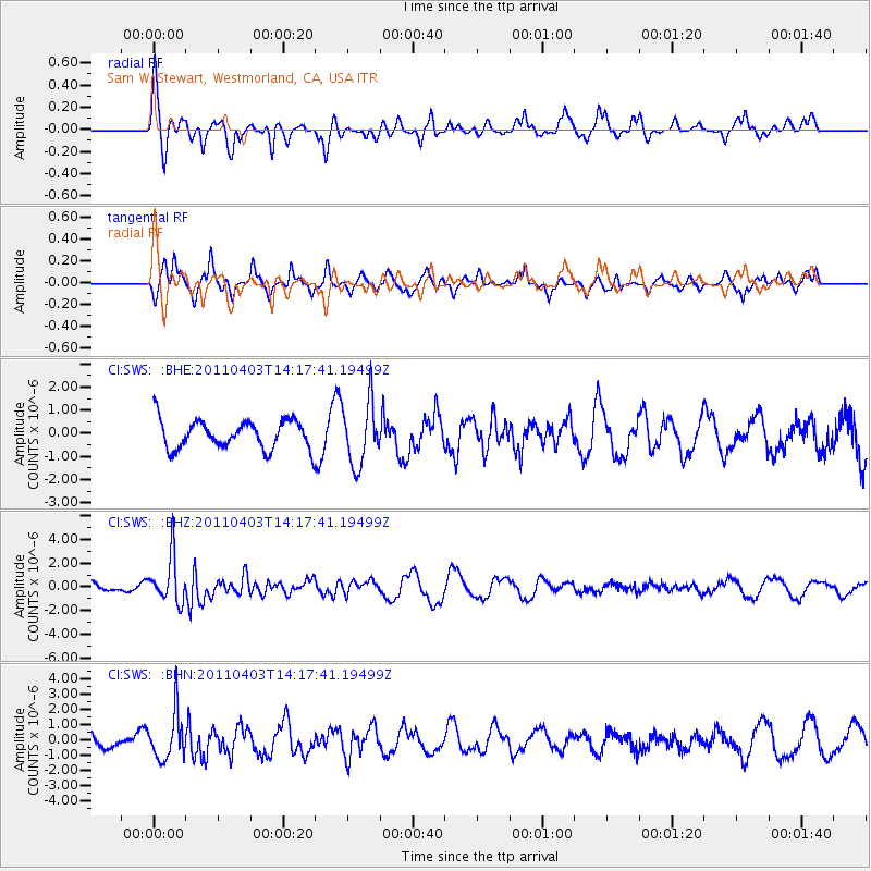
SWS Sam W. Stewart, Westmorland, CA, USA - Earthquake Result Viewer
*The percent match for this event was below the threshold and hence no stack was calculated.
| Earthquake location: |
Fiji Islands Region |
| Earthquake latitude/longitude: |
-17.6/-178.6 |
| Earthquake time(UTC): |
2011/04/03 (093) 14:07:09 GMT |
| Earthquake Depth: |
552 km |
| Earthquake Magnitude: |
5.6 MB, 6.4 MW, 6.4 MW |
| Earthquake Catalog/Contributor: |
WHDF/NEIC |
|
| Network: |
CI Caltech Regional Seismic Network |
| Station: |
SWS Sam W. Stewart, Westmorland, CA, USA |
| Lat/Lon: |
32.94 N/115.80 W |
| Elevation: |
140 m |
|
| Distance: |
78.3 deg |
| Az: |
49.804 deg |
| Baz: |
240.017 deg |
| Ray Param: |
$rayparam |
*The percent match for this event was below the threshold and hence was not used in the summary stack. |
|
| Radial Match: |
61.815308 % |
| Radial Bump: |
318 |
| Transverse Match: |
71.57576 % |
| Transverse Bump: |
317 |
| SOD ConfigId: |
356183 |
| Insert Time: |
2011-09-23 11:52:10.572 +0000 |
| GWidth: |
2.5 |
| Max Bumps: |
400 |
| Tol: |
0.001 |
|
Signal To Noise
| Channel | StoN | STA | LTA |
| CI:SWS: :BHZ:20110403T14:17:41.19499Z | 4.282576 | 1.942788E-6 | 4.5364942E-7 |
| CI:SWS: :BHN:20110403T14:17:41.19499Z | 2.2054677 | 1.5094757E-6 | 6.844243E-7 |
| CI:SWS: :BHE:20110403T14:17:41.19499Z | 2.2055655 | 1.3559101E-6 | 6.1476754E-7 |
| Arrivals |
| Ps | |
| PpPs | |
| PsPs/PpSs | |


