You are here: Home > Network List > CI - Caltech Regional Seismic Network Stations List
> Station MPM Manuel Prospect Mine, California, USA > Earthquake Result Viewer
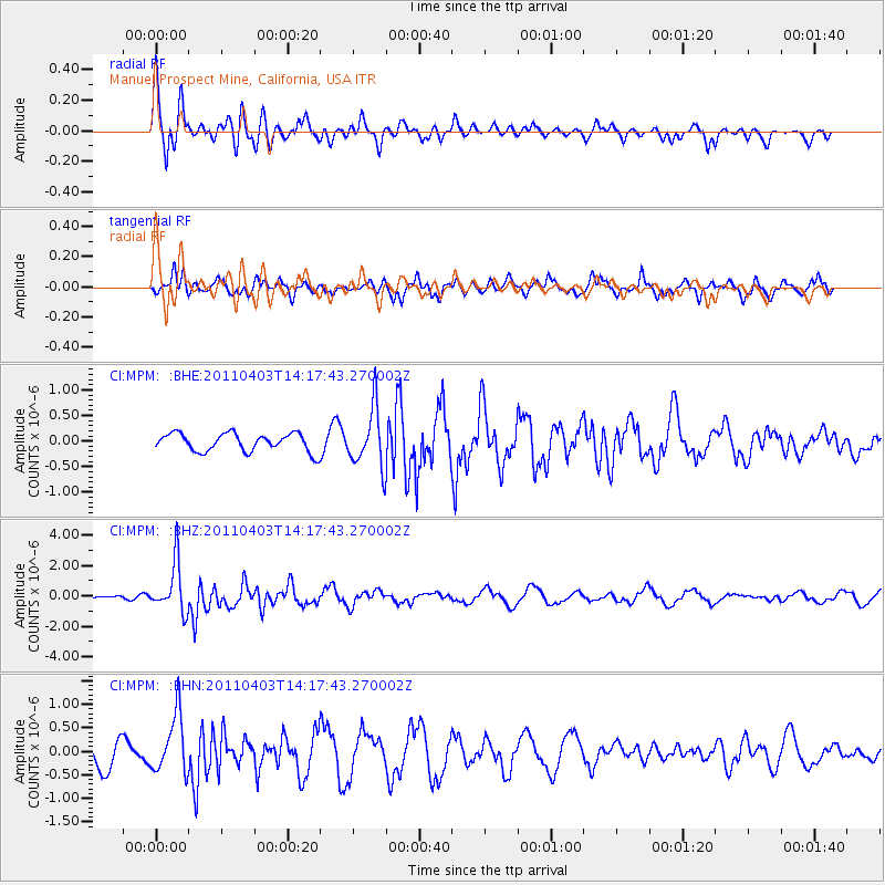
MPM Manuel Prospect Mine, California, USA - Earthquake Result Viewer
*The percent match for this event was below the threshold and hence no stack was calculated.
| Earthquake location: |
Fiji Islands Region |
| Earthquake latitude/longitude: |
-17.6/-178.6 |
| Earthquake time(UTC): |
2011/04/03 (093) 14:07:09 GMT |
| Earthquake Depth: |
552 km |
| Earthquake Magnitude: |
5.6 MB, 6.4 MW, 6.4 MW |
| Earthquake Catalog/Contributor: |
WHDF/NEIC |
|
| Network: |
CI Caltech Regional Seismic Network |
| Station: |
MPM Manuel Prospect Mine, California, USA |
| Lat/Lon: |
36.06 N/117.49 W |
| Elevation: |
185 m |
|
| Distance: |
78.6 deg |
| Az: |
46.347 deg |
| Baz: |
238.369 deg |
| Ray Param: |
$rayparam |
*The percent match for this event was below the threshold and hence was not used in the summary stack. |
|
| Radial Match: |
77.50294 % |
| Radial Bump: |
400 |
| Transverse Match: |
55.573166 % |
| Transverse Bump: |
365 |
| SOD ConfigId: |
356183 |
| Insert Time: |
2011-09-23 11:52:39.107 +0000 |
| GWidth: |
2.5 |
| Max Bumps: |
400 |
| Tol: |
0.001 |
|
Signal To Noise
| Channel | StoN | STA | LTA |
| CI:MPM: :BHZ:20110403T14:17:43.270002Z | 9.765538 | 1.6307949E-6 | 1.6699488E-7 |
| CI:MPM: :BHN:20110403T14:17:43.270002Z | 2.3173025 | 6.219135E-7 | 2.6837822E-7 |
| CI:MPM: :BHE:20110403T14:17:43.270002Z | 3.2886662 | 5.7965104E-7 | 1.7625717E-7 |
| Arrivals |
| Ps | |
| PpPs | |
| PsPs/PpSs | |


