You are here: Home > Network List > AZ - ANZA Regional Network Stations List
> Station SHUM AZ.SHUM > Earthquake Result Viewer
SHUM AZ.SHUM - Earthquake Result Viewer
| Earthquake location: |
Southern Bolivia |
| Earthquake latitude/longitude: |
-22.0/-65.7 |
| Earthquake time(UTC): |
1997/01/23 (023) 02:15:22 GMT |
| Earthquake Depth: |
276 km |
| Earthquake Magnitude: |
6.4 MB, 7.1 UNKNOWN, 7.1 MW |
| Earthquake Catalog/Contributor: |
WHDF/NEIC |
|
| Network: |
AZ ANZA Regional Network |
| Station: |
SHUM AZ.SHUM |
| Lat/Lon: |
33.63 N/116.44 W |
| Elevation: |
1195 m |
|
| Distance: |
73.5 deg |
| Az: |
317.641 deg |
| Baz: |
131.455 deg |
| Ray Param: |
0.052214764 |
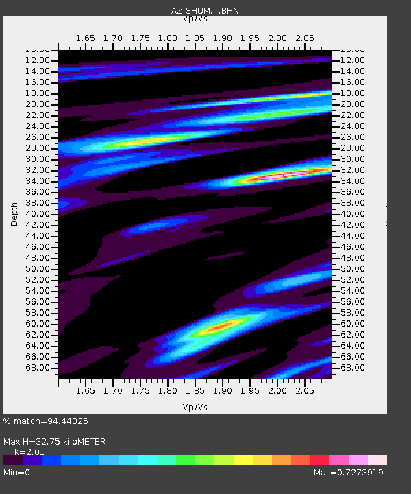
| Estimated Moho Depth: |
32.75 km |
| Estimated Crust Vp/Vs: |
2.01 |
| Assumed Crust Vp: |
6.264 km/s |
| Estimated Crust Vs: |
3.116 km/s |
| Estimated Crust Poisson's Ratio: |
0.34 |
|
| Radial Match: |
94.44825 % |
| Radial Bump: |
400 |
| Transverse Match: |
79.4551 % |
| Transverse Bump: |
400 |
| SOD ConfigId: |
6273 |
| Insert Time: |
2010-02-26 20:41:00.494 +0000 |
| GWidth: |
2.5 |
| Max Bumps: |
400 |
| Tol: |
0.001 |
|
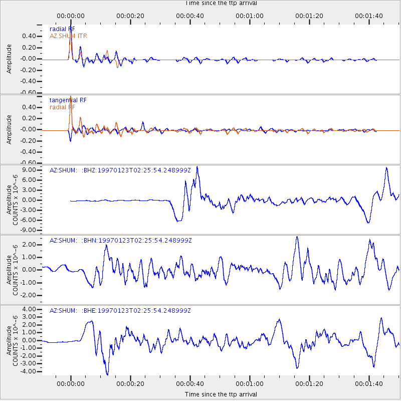
Signal To Noise
| Channel | StoN | STA | LTA |
| AZ:SHUM: :BHN:19970123T02:25:54.248999Z | 0.41988993 | 9.7909E-8 | 2.3317777E-7 |
| AZ:SHUM: :BHE:19970123T02:25:54.248999Z | 3.155634 | 5.778522E-7 | 1.8311762E-7 |
| AZ:SHUM: :BHZ:19970123T02:25:54.248999Z | 11.146698 | 1.2193807E-6 | 1.0939389E-7 |
| Arrivals |
| Ps | 5.4 SECOND |
| PpPs | 15 SECOND |
| PsPs/PpSs | 21 SECOND |


