You are here: Home > Network List > CI - Caltech Regional Seismic Network Stations List
> Station RCT Rector, Visalia, CA, USA > Earthquake Result Viewer
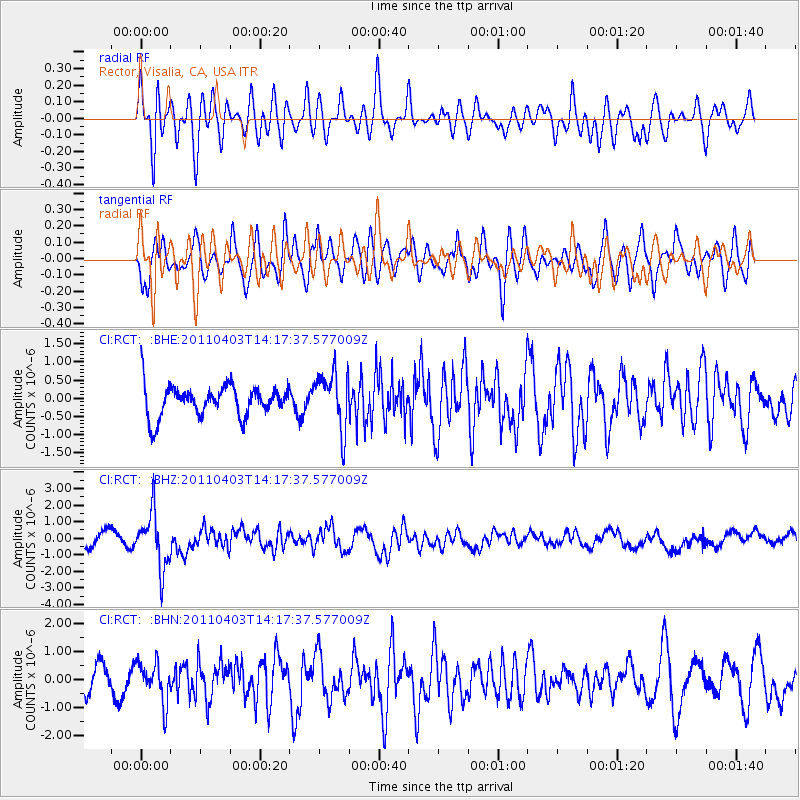
RCT Rector, Visalia, CA, USA - Earthquake Result Viewer
*The percent match for this event was below the threshold and hence no stack was calculated.
| Earthquake location: |
Fiji Islands Region |
| Earthquake latitude/longitude: |
-17.6/-178.6 |
| Earthquake time(UTC): |
2011/04/03 (093) 14:07:09 GMT |
| Earthquake Depth: |
552 km |
| Earthquake Magnitude: |
5.6 MB, 6.4 MW, 6.4 MW |
| Earthquake Catalog/Contributor: |
WHDF/NEIC |
|
| Network: |
CI Caltech Regional Seismic Network |
| Station: |
RCT Rector, Visalia, CA, USA |
| Lat/Lon: |
36.31 N/119.24 W |
| Elevation: |
107 m |
|
| Distance: |
77.6 deg |
| Az: |
45.359 deg |
| Baz: |
237.134 deg |
| Ray Param: |
$rayparam |
*The percent match for this event was below the threshold and hence was not used in the summary stack. |
|
| Radial Match: |
57.771255 % |
| Radial Bump: |
400 |
| Transverse Match: |
61.236126 % |
| Transverse Bump: |
400 |
| SOD ConfigId: |
356183 |
| Insert Time: |
2011-09-23 11:56:07.863 +0000 |
| GWidth: |
2.5 |
| Max Bumps: |
400 |
| Tol: |
0.001 |
|
Signal To Noise
| Channel | StoN | STA | LTA |
| CI:RCT: :BHZ:20110403T14:17:37.577009Z | 4.7835574 | 1.694976E-6 | 3.543338E-7 |
| CI:RCT: :BHN:20110403T14:17:37.577009Z | 1.229544 | 6.938428E-7 | 5.64309E-7 |
| CI:RCT: :BHE:20110403T14:17:37.577009Z | 1.8209364 | 7.805111E-7 | 4.2863167E-7 |
| Arrivals |
| Ps | |
| PpPs | |
| PsPs/PpSs | |


