You are here: Home > Network List > AZ - ANZA Regional Network Stations List
> Station SHUM AZ.SHUM > Earthquake Result Viewer
SHUM AZ.SHUM - Earthquake Result Viewer
| Earthquake location: |
Tonga Islands |
| Earthquake latitude/longitude: |
-19.9/-173.3 |
| Earthquake time(UTC): |
1997/02/07 (038) 08:41:13 GMT |
| Earthquake Depth: |
28 km |
| Earthquake Magnitude: |
6.0 MB, 6.2 MS, 6.4 UNKNOWN, 6.0 ME |
| Earthquake Catalog/Contributor: |
WHDF/NEIC |
|
| Network: |
AZ ANZA Regional Network |
| Station: |
SHUM AZ.SHUM |
| Lat/Lon: |
33.63 N/116.44 W |
| Elevation: |
1195 m |
|
| Distance: |
75.9 deg |
| Az: |
46.065 deg |
| Baz: |
234.334 deg |
| Ray Param: |
0.051308997 |
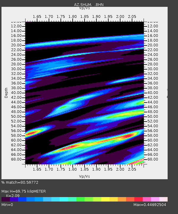
| Estimated Moho Depth: |
69.75 km |
| Estimated Crust Vp/Vs: |
2.09 |
| Assumed Crust Vp: |
6.264 km/s |
| Estimated Crust Vs: |
2.997 km/s |
| Estimated Crust Poisson's Ratio: |
0.35 |
|
| Radial Match: |
80.59772 % |
| Radial Bump: |
400 |
| Transverse Match: |
68.66976 % |
| Transverse Bump: |
400 |
| SOD ConfigId: |
6273 |
| Insert Time: |
2010-02-26 20:41:01.500 +0000 |
| GWidth: |
2.5 |
| Max Bumps: |
400 |
| Tol: |
0.001 |
|
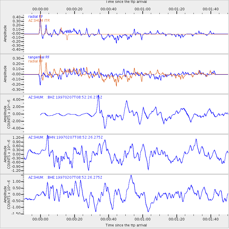
Signal To Noise
| Channel | StoN | STA | LTA |
| AZ:SHUM: :BHN:19970207T08:52:26.275Z | 1.9606403 | 6.976769E-7 | 3.5584137E-7 |
| AZ:SHUM: :BHE:19970207T08:52:26.275Z | 2.0466592 | 5.328162E-7 | 2.603346E-7 |
| AZ:SHUM: :BHZ:19970207T08:52:26.275Z | 9.412334 | 2.110939E-6 | 2.242737E-7 |
| Arrivals |
| Ps | 12 SECOND |
| PpPs | 34 SECOND |
| PsPs/PpSs | 46 SECOND |


