You are here: Home > Network List > IW - Intermountain West Stations List
> Station MOOW Moose Ponds, Wyoming, USA > Earthquake Result Viewer
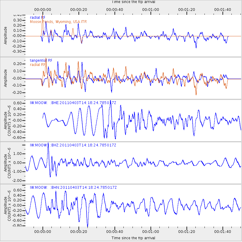
MOOW Moose Ponds, Wyoming, USA - Earthquake Result Viewer
*The percent match for this event was below the threshold and hence no stack was calculated.
| Earthquake location: |
Fiji Islands Region |
| Earthquake latitude/longitude: |
-17.6/-178.6 |
| Earthquake time(UTC): |
2011/04/03 (093) 14:07:09 GMT |
| Earthquake Depth: |
552 km |
| Earthquake Magnitude: |
5.6 MB, 6.4 MW, 6.4 MW |
| Earthquake Catalog/Contributor: |
WHDF/NEIC |
|
| Network: |
IW Intermountain West |
| Station: |
MOOW Moose Ponds, Wyoming, USA |
| Lat/Lon: |
43.75 N/110.74 W |
| Elevation: |
2128 m |
|
| Distance: |
87.0 deg |
| Az: |
42.231 deg |
| Baz: |
242.174 deg |
| Ray Param: |
$rayparam |
*The percent match for this event was below the threshold and hence was not used in the summary stack. |
|
| Radial Match: |
70.909134 % |
| Radial Bump: |
400 |
| Transverse Match: |
69.98363 % |
| Transverse Bump: |
381 |
| SOD ConfigId: |
356183 |
| Insert Time: |
2011-09-23 12:21:06.928 +0000 |
| GWidth: |
2.5 |
| Max Bumps: |
400 |
| Tol: |
0.001 |
|
Signal To Noise
| Channel | StoN | STA | LTA |
| IW:MOOW: :BHZ:20110403T14:18:24.785017Z | 2.1499116 | 8.8083516E-7 | 4.097076E-7 |
| IW:MOOW: :BHN:20110403T14:18:24.785017Z | 1.6644585 | 2.7065667E-7 | 1.6260945E-7 |
| IW:MOOW: :BHE:20110403T14:18:24.785017Z | 1.7804344 | 3.7789766E-7 | 2.1225026E-7 |
| Arrivals |
| Ps | |
| PpPs | |
| PsPs/PpSs | |


