You are here: Home > Network List > AZ - ANZA Regional Network Stations List
> Station SHUM AZ.SHUM > Earthquake Result Viewer
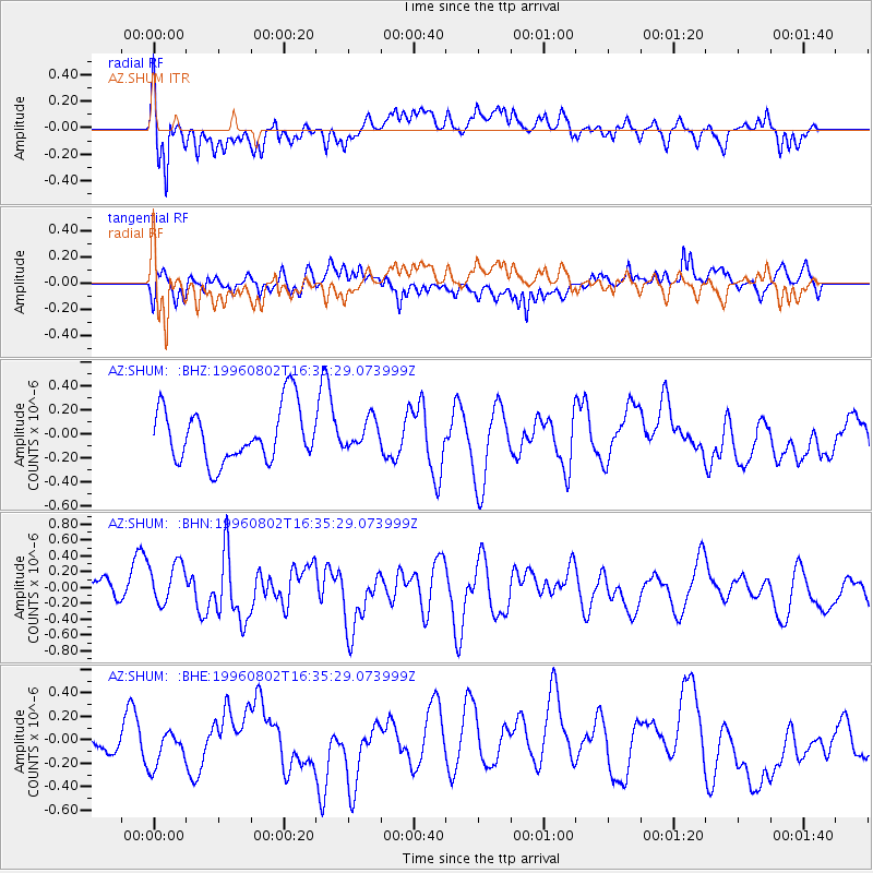
SHUM AZ.SHUM - Earthquake Result Viewer
*The percent match for this event was below the threshold and hence no stack was calculated.
| Earthquake location: |
South Of Fiji Islands |
| Earthquake latitude/longitude: |
-26.9/-177.2 |
| Earthquake time(UTC): |
1996/08/02 (215) 16:23:36 GMT |
| Earthquake Depth: |
33 km |
| Earthquake Magnitude: |
5.7 MS, 5.3 MB |
| Earthquake Catalog/Contributor: |
WHDF/NEIC |
|
| Network: |
AZ ANZA Regional Network |
| Station: |
SHUM AZ.SHUM |
| Lat/Lon: |
33.63 N/116.44 W |
| Elevation: |
1195 m |
|
| Distance: |
83.3 deg |
| Az: |
47.114 deg |
| Baz: |
231.638 deg |
| Ray Param: |
$rayparam |
*The percent match for this event was below the threshold and hence was not used in the summary stack. |
|
| Radial Match: |
58.34178 % |
| Radial Bump: |
400 |
| Transverse Match: |
56.93911 % |
| Transverse Bump: |
400 |
| SOD ConfigId: |
4480 |
| Insert Time: |
2010-02-26 20:41:09.744 +0000 |
| GWidth: |
2.5 |
| Max Bumps: |
400 |
| Tol: |
0.001 |
|
Signal To Noise
| Channel | StoN | STA | LTA |
| AZ:SHUM: :BHN:19960802T16:35:29.073999Z | 1.2486175 | 2.7782133E-7 | 2.2250313E-7 |
| AZ:SHUM: :BHE:19960802T16:35:29.073999Z | 0.5902168 | 2.2767887E-7 | 3.8575465E-7 |
| AZ:SHUM: :BHZ:19960802T16:35:29.073999Z | 0.50640374 | 1.1423299E-7 | 2.255769E-7 |
| Arrivals |
| Ps | |
| PpPs | |
| PsPs/PpSs | |


