You are here: Home > Network List > AZ - ANZA Regional Network Stations List
> Station SHUM AZ.SHUM > Earthquake Result Viewer
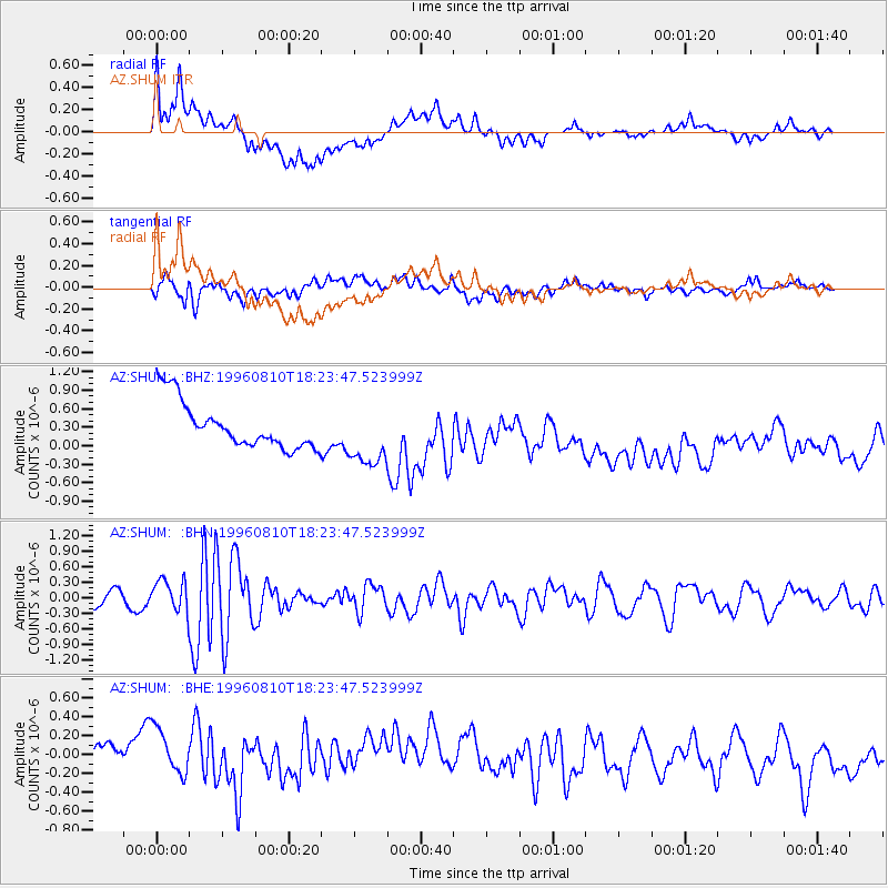
SHUM AZ.SHUM - Earthquake Result Viewer
*The percent match for this event was below the threshold and hence no stack was calculated.
| Earthquake location: |
Eastern Honshu, Japan |
| Earthquake latitude/longitude: |
38.9/140.5 |
| Earthquake time(UTC): |
1996/08/10 (223) 18:12:17 GMT |
| Earthquake Depth: |
10 km |
| Earthquake Magnitude: |
6.0 MB, 5.7 MS, 5.9 UNKNOWN, 5.9 MW |
| Earthquake Catalog/Contributor: |
WHDF/NEIC |
|
| Network: |
AZ ANZA Regional Network |
| Station: |
SHUM AZ.SHUM |
| Lat/Lon: |
33.63 N/116.44 W |
| Elevation: |
1195 m |
|
| Distance: |
78.6 deg |
| Az: |
56.026 deg |
| Baz: |
309.15 deg |
| Ray Param: |
$rayparam |
*The percent match for this event was below the threshold and hence was not used in the summary stack. |
|
| Radial Match: |
33.38591 % |
| Radial Bump: |
400 |
| Transverse Match: |
58.250717 % |
| Transverse Bump: |
400 |
| SOD ConfigId: |
4480 |
| Insert Time: |
2010-02-26 20:41:12.330 +0000 |
| GWidth: |
2.5 |
| Max Bumps: |
400 |
| Tol: |
0.001 |
|
Signal To Noise
| Channel | StoN | STA | LTA |
| AZ:SHUM: :BHN:19960810T18:23:47.523999Z | 2.2150917 | 3.0545797E-7 | 1.3789857E-7 |
| AZ:SHUM: :BHE:19960810T18:23:47.523999Z | 1.2088513 | 3.241107E-7 | 2.681146E-7 |
| AZ:SHUM: :BHZ:19960810T18:23:47.523999Z | 1.3642215 | 5.1466753E-7 | 3.77261E-7 |
| Arrivals |
| Ps | |
| PpPs | |
| PsPs/PpSs | |


