You are here: Home > Network List > AK - Alaska Regional Network Stations List
> Station MLY Manley Hot Springs, Alaska, USA > Earthquake Result Viewer
MLY Manley Hot Springs, Alaska, USA - Earthquake Result Viewer
| Earthquake location: |
Near East Coast Of Honshu, Japan |
| Earthquake latitude/longitude: |
38.3/141.6 |
| Earthquake time(UTC): |
2011/04/07 (097) 14:32:43 GMT |
| Earthquake Depth: |
42 km |
| Earthquake Magnitude: |
6.9 MB, 7.0 MS, 7.1 MW, 7.1 MW |
| Earthquake Catalog/Contributor: |
WHDF/NEIC |
|
| Network: |
AK Alaska Regional Network |
| Station: |
MLY Manley Hot Springs, Alaska, USA |
| Lat/Lon: |
65.03 N/150.74 W |
| Elevation: |
804 m |
|
| Distance: |
46.7 deg |
| Az: |
32.634 deg |
| Baz: |
269.301 deg |
| Ray Param: |
0.07036034 |
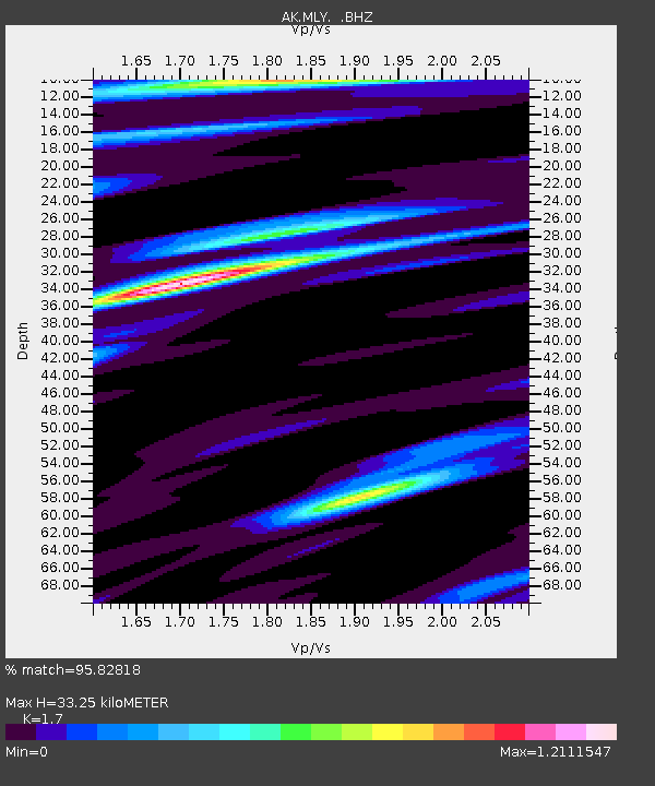
| Estimated Moho Depth: |
33.25 km |
| Estimated Crust Vp/Vs: |
1.70 |
| Assumed Crust Vp: |
6.566 km/s |
| Estimated Crust Vs: |
3.862 km/s |
| Estimated Crust Poisson's Ratio: |
0.24 |
|
| Radial Match: |
95.82818 % |
| Radial Bump: |
400 |
| Transverse Match: |
93.91647 % |
| Transverse Bump: |
400 |
| SOD ConfigId: |
356183 |
| Insert Time: |
2011-09-23 13:11:51.281 +0000 |
| GWidth: |
2.5 |
| Max Bumps: |
400 |
| Tol: |
0.001 |
|

Signal To Noise
| Channel | StoN | STA | LTA |
| AK:MLY: :BHZ:20110407T14:40:37.68801Z | 13.561026 | 6.386951E-6 | 4.7097848E-7 |
| AK:MLY: :BHN:20110407T14:40:37.68801Z | 5.1686277 | 1.907822E-6 | 3.6911575E-7 |
| AK:MLY: :BHE:20110407T14:40:37.68801Z | 7.370549 | 3.0785243E-6 | 4.176791E-7 |
| Arrivals |
| Ps | 3.8 SECOND |
| PpPs | 13 SECOND |
| PsPs/PpSs | 17 SECOND |


